Category Archives: London Parks

Perambulations Through Late Georgian London or, All the Best Sights in One Week. Day Five

It’s a Friday in 1836  and, if you have been reading my previous four posts following Mr Whittock’s London tourist itinerary, you may be hoping the visitors are going to have a restful day today. I’m afraid not – they will have to wait until Sunday for that!

West end: walk to St. James’;

Mr Whittock recommended taking lodgings around Charing Cross, so the visitors would begin by walking around the southern edge of the Trafalgar Square building site and then down Pall Mall, passing through Waterloo Place, the southern end of Regent Street and continuing westwards.

The print, from Ackermann’s Repository, shows the view looking back the way they had come. We are facing down the Strand with Northumberland House (demolished 1874) on the right. The site of Trafalgar Square is over our left shoulder and Whitehall runs off to the right. The statue is the only landmark we would recognise today – King Charles I looking down towards his place of execution. I blogged about it more extensively here.

see the Palace,

St James’s Palace, at the foot of St James’s Street, was not open to the public, but the Tudor red brick exterior with its guards was as interesting a sight then as it is, almost unchanged, now. It was no longer the residence of the monarch – that had moved to what is now Buckingham Palace – but it remained the main location for Drawing Rooms, the reception of Ambassadors and all the formal business of royalty. You can read more about it in two parts,  here and here.

The Palace in 1809

Club-houses,

The visitors would have already passed the Athenaeum in Waterloo Place, but a stroll up and down St James’s Street would allow them to see (from the outside only, of course!) Boodles (a favourite of country squires), White’s (the oldest and smartest), Crockford’s (famous for its gambling) and Brooks’s, one of Byron’s clubs, (seen in the print, 1808 – the room looks just the same today with the same tables)

In one corner of the Great Subscription Room a tense game is underway with a large pot of winnings in the centre

and British Gallery, if open;

That would involve walking back along Pall Mall a little to number 52, the home of the British Institution.  Otherwise known as Pall Mall Picture Galleries or the British Gallery, it was founded in 1805 and was considered elitist and conservative by many artists. It was disbanded in 1867. The print from Ackermann’s Repository (1805) shows artists copying the works on display. Interestingly, four of the seven artists are women.

walk through the Park,

This was Green Park and the visitor could access it by walking past the front of St James’s Palace.

see the New Palace, and York House;

They would see the imposing façade of York House, now renamed Lancaster House, on their left just before they entered the Park. (The modern visitor has to take a rather more circuitous route). The house is now managed by the Foreign and Commonwealth Office and is let out for filming, London Fashion Week, conferences and so on. It was commissioned in 1825 for ‘the grand old Duke of York’ – Prince Frederick, Duke of York and Albany – of the nursery rhyme. The website gives more of its history and some pictures of the lavish interior.

This is the view across Green Park, captioned “The Queen’s Palace from the Green Park.” It was printed in The Beauties of England and Wales published c. 1815. You can see the chimneys of the Palace on the right and some of Green Park’s famous dairy cows.

The New Palace is Buckingham Palace and would not have been open to the public. It was built as Buckingham House 1702-5 by the Duke of Buckingham and his wife, an illegitimate daughter of the deposed James II. The Buckinghams created the most opulent private house in London, apparently as a snub to the ‘usurping’ Hanoverians in their ramshackle Tudor palace across the park. George II bought it in 1762 for his wife and it became known as The Queen’s House, then, after her death, as The King’s House. His son, George IV, decided that his own palace at Carlton House was no longer adequate when he came to the throne and put in train elaborate and vastly expensive plans to enlarge and remodel the house in its stead. The final bill was £700,000, despite the Duke of Wellington, when Prime Minister in 1828, declaring, ‘If you expect me to put my hand to any additional expense, I’ll be damned if I will.’

It wasn’t finished when George IV died and his brother and successor, William IV never lived there. It was inherited by Queen Victoria in 1837 in a dreadful state – the drainage was abysmal, the windows would not open, the bells did not function…  Work continued throughout the 19th century with the final major change being the Portland stone façade on the east front in 1913.

 walk through the Green Park to Hyde Park;

This path would have been along the line of the present Constitution Road with the high walls of the Palace gardens on the left. The area in the angle formed by the junction of Piccadilly and the Palace wall was known as Constitution Hill, although there is no record of where it got that name.

see the Triumphal Arch,

This is the Wellington Arch designed by Decimus Burton. It was originally part of a scheme for improving the approach to Buckingham Palace but, just as the basic work was completed in 1828, funding cuts as a result of the vast Palace overspend left it without any of the intended decoration. In the 1830s committees were overseeing the erection of monuments to the two great military heroes, Nelson and Wellington. Nelson’s Column was achieved with little controversy but in 1838 an ill-judged decision was made to place a vast statue of the Duke on top of the arch. It was erected in 1846 to general mockery and disapproval for its disproportionate size, but the Duke threatened to resign all his posts if it was removed, seeing that as a personal slight. Eventually in 1883, when the arch itself was moved slightly to its present position in the centre of Hyde Park Corner, it was sent to Aldershot. The interior of the arch can be visited and you can see images of the original design and the arch with the statue in place on the English Heritage website.

and Statue of Achilles.

Mr Herriot’s tourists would have seen only the unadorned arch, but they would have been able to view the colossal statue of Achilles just inside the park gates behind Apsley House in all its glory. It was cast from captured French guns in 1822 to be given ‘by the women of England to Arthur Duke of Wellington and his brave companions in arms.’ Not only was it six metres high but it was completely nude – with everything in proportion. The outcry was such that a small fig leaf was added, causing further complaints that it was not large enough!

The Cruikshank print is entitled Monstrosities of London (1822) and it is the dandies and the ladies in their highly fashionable outfits that are being caricatured. The statue already has its fig leaf!

At Oxford Street Gate, ride to the Zoological Gardens, spend two hours,

The Zoological Society of London was founded in 1826 and its collection of animals was opened in 1828 on the site at the north of Regent’s Park. There were 30,000 visitors in the first seven months. The contents of the Rooyal Menagerie from Windsor were added in 1830 and the animals from the Tower of London were moved there in 1832-4. Mr Herriott’s visitors would have been able to view monkeys, bears, llamas, zebras, kangaroos, emus, turtles, an Indian elephant, an alligator, huge snakes, Tommy the chimpanzee, four giraffes and visit the camel house (shown in the print of 1835).

 return by Portland Place to Oxford Street; visit the Bazaars,

There were shops in Oxford Street, but it was not until later in the century that the great department stores we associate it with now were developed. It would have had many smaller shops and bazaars which would have been cheaper than the establishments in, for example, Bond Street.

return home, dine, and in the evening, visit Braham’s New Theatre, recently erected in King Street, St. James Square.

The theatre, better known as the St James’s Theatre, was situated immediately opposite the junction with Bury Street. It was demolished in 1957 and replaced by a bland office block.

This theatre is the last erected, and is certainly the most beautiful minor theatre in the metropolis; it is opened under a licence from the lord chamberlain, granted to this favoured votary of Apollo, who has been the leading singer, not only of England, but of Europe, upwards of thirty years. The exterior is plain, but the interior is superb. The boxes are supported by cariatydes [sic], and the ornaments are of the most gorgeous description, in the style used in France during the reign of Louis XIV. The performances are operas, and farces; Braham frequently appears in both, and being seconded by an excellent company, it would be a matter of surprise if the theatre was not fashionably and numerously attended. The prices of admission are, to the boxes, five shillings; pit, three shillings; gallery, one shilling and sixpence: the half-price commences at nine o’clock.

One has to wonder whether Mr Whittock was getting paid for this detailed endorsement. The theatre was a vanity project of opera star John Braham which cost him £28,000 to build. The programme was, apparently, considered unexciting and the location too far west and it consistently lost money – even ‘going dark’ in 1841. It struggled on into the 20th century under numerous managements, maintaining a reputation as an unlucky theatre. The print is by Crace, 1835, and supports Mr Whittock’s enthusiasm about the interior.

If you would like to try more detailed perambulations yourself you will find Hyde Park Corner in Walk 1 and St James’s and Pall Mall in Walk 4 of Walking Jane Austen’s London and Walks 1 & 2 of Walks Through Regency London.

1 Comment

Filed under Animals, Architecture, Art, Buildings, Entertainment, Fashions, London Parks, Monuments, Regency caricatures, Shopping, Walks, Wellington

Perambulations Through Late Georgian London or, All the Best Sights in One Week. Day Four

It’s Thursday, the fourth day of the London sightseeing programme proposed by Nathaniel Whittock in 1836. By now the tourists are either on their knees with exhaustion or getting their second wind after the itineraries described in my previous three posts. They might be relieved to find that there is a fair amount of riding around involved in today’s expedition. This itinerary illustrates more clearly than any of the others how close to the Victorian era these visitors are as they experience engineering marvels and improvements in public transport.

Get into the omnibus or coach that goes to Blackwall.

Mr Whittock informs us that “Omnibusses [sic] now run through the leading thoroughfares: their charge is generally stated on the outside of the carriage. At the present time it is as cheap as the most rigid economist could desire as a person may ride in a handsome vehicle from the Bank to Paddington, a distance of four miles, for sixpence.”

George Shillibeer brought horse-drawn omnibuses (shown in the print above) to London in 1829, having seen them operating in Paris. At first they operated with a conductor who took the fares but did not issue tickets. He recorded all the transactions on a waybill, then paid his own, and the driver’s, wages from the money collected and handed the rest over to the bus owner.

An account of the new service was given in the Morning Post of 7 July 1829. “Saturday the new vehicle, called the Omnibus, commenced running from Paddington to the City, and excited considerable notice, both from the novel form of the carriage, and the elegance with which it is fitted out. It is capable of accommodating 16 or 18 persons, all inside, and we apprehend it would be almost impossible to make it overturn, owing to the great width of the carriage. It was drawn by three beautiful bays abreast, after the French fashion. The Omnibus is a handsome machine, in the shape of a van. The width the horses occupy will render the vehicle rather inconvenient to be turned or driven through some of the streets of London.”

see the East and West India Docks


The London docks must have been a spectacular sight, teeming with a mass of sailing ships from all parts of the world. The print is a detail from a painting of 1802, looking west across the neck of the Isle of Dogs towards the City, and showing the West India Dock, opened that year. The import dock is on the right, the dock on the left is for export. The canal on the left later became the South Dock. The East India Docks were slightly to the east at the top of the northward bend of the Blackwall Reach of the Thames. Surrounding the docks were huge secure warehouses with walls thirty feet high and their own guards, an effective protection against the menace of ‘limpers’, ‘water pads’ and ‘water sneaks’ who preyed on the craft moored in the river itself.

The map shows the docks in 1849.

A short walk thence will take you to the Ferry-House. On crossing the Thames, see Greenwich Hospital.

These days an entire day can easily be spent in Greenwich but Mr Whittock merely invites his readers to admire the exterior of the buildings (he doesn’t even mention the Queen’s House), enter the Great Hall and look up the hill to the Observatory – ‘a conspicuous and celebrated Object.’

Ride on the Railroad as far as Bermondsey;

This would have been a real highlight for visitors – the first railway line in London. It was intended only for passengers and was built from London Bridge to Greenwich on a viaduct twenty two feet above the ground and supported on “nearly a thousand arches…intended to be converted into dwelling-houses or places of business.” It cut the journey time from London Bridge to Greenwich from an hour to ten minutes and was the forerunner of all the London commuter lines.

 walk to Rotherhithe, devote an hour to the examination of the Tunnel.

Interestingly, Mr Whittock seems more excited about the Thames Tunnel than he does about the railway. It was certainly an epic piece of engineering, during the course of which Marc Brunel (father of Isambard Kingdom Brunel) invented the tunnel shield which is the basis of all tunnel-boring today. Made essential by the development of the docks, and the problems of building bridges over the Thames to bring the workers from south of the river, it was intended for carriage traffic but instead became a footway and a major tourist attraction. It was converted to take the East London railway line in 1869. The print is from 1835.

Dine at Rotherhithe, and afterwards ride to the Surrey Zoological Gardens.

The Surrey Zoological Society Gardens were founded in 1831 and occupied a site now under Penton Place in Walworth, just north-east of the Oval cricket ground. Impressario Edward Cross sold them the contents of his menagerie at Exeter Change which I blogged about here. It must have been some improvement for the animals who were housed in cages under a circular domed glass conservatory 300 feet (90 m) in circumference. There were lions, tigers, a rhinoceros and giraffes (shown here in 1841) and, for a time, the gardens were more popular than London Zoo in Regent’s Park. However, that was subsidised, and cheaper (the Surrey Gardens cost one shilling admission), so gained in popularity. The gardens, which were lavishly planted and dotted with pavilions, were used for large public entertainments from 1837 – re-enactments of the eruption of Mount Vesuvius, the Great Fire of London, or the storming of Badajoz – and spectacular firework displays. The Great Exhibition of 1851 was the final nail in its coffin and it closed in 1856.

Towards the evening return to dress, and at eight o’clock go by water to Vauxhall.

Vauxhall Gardens lay where the modern park is still situated, close to the Thames and Vauxhall Bridge. Going by water was the traditional way of visiting, even though the first bridge had opened in 1816.

I have blogged about Vauxhall Pleasure Gardens here and also in comparison with their rival, Ranelagh. The print by Cruickshank shows the Gardens in the 1830s, just as our tourists must have seen them.

They would have staggered back to their lodgings late and perhaps a trifle tipsy. Hopefully they get a decent night’s sleep, because Friday will be devoted to the West End, London Zoo, shopping and the theatre.

If you are interested in more of the slang used for London’s criminal classes, including the river thieves, you can find that, and much more, here

1 Comment

Filed under Animals, Architecture, Buildings, Crime, Entertainment, London Parks, Rivers, Science & technology, Transport and travel

Perambulations Through Late Georgian London or, All the Best Sights in One Week. Day Three

After  exhaustive (and exhausting) sightseeing on Monday and Tuesday, described in my previous two posts, Mr Whittock (The Modern Picture of London, 1836) has a far shorter list of places to visit for Wednesday. I suspect it would not be much less demanding.

He begins by instructing the tourist to Visit the Adelaide Gallery in Adelaide Street. This was a new street at the time Mr Whittock was writing and was part of the redevelopment of the area that is now Trafalgar Square and the National Gallery and which was the King’s and Queen’s Mews and the St Martin’s Workhouse, the Golden Cross Inn, the Phoenix Insurance company’s fire station and assorted small dwellings and workshops.

The site was cleared in 1830 but work on the hard landscaping of the Square did not begin until 1840. Those visitors guided by Mr Whittock would have seen a vast building site.

Adelaide Street runs from the Strand northwards behind St Martin in the Fields church (seen in the image of 1815). The Adelaide Gallery of Science and Art was one of the most interesting and rational exhibitions in London… and contains models of the most curious discoveries in mechanics, engineering etc. Perkin’s celebrated steam gun, the modern diving bell, the model of the process of distillation from bread and hundreds of other curiosities are exhibited here. The rooms are open daily, the admission is one shilling, and it is impossible to spend a shilling at any other exhibition in London where so much amusement and information may be gained.

Jacob Perkins, an American, patented his steam gun in 1824 and tests showed that it could fire projectiles at great pressure and could even work as a machine gun. The Duke of Wellington became interested, so did the French, the Russians and the Turks. It all came to nothing in the end in a quagmire of government indecision about spending, prejudice against ‘colonials’ and the improvement of more conventional weapons.

The London Mechanics’ Register in November 1824 wrote, If Mr. Perkins’s steam guns were introduced into general use, there would be but very short wars; since no fecundity could provide population for its attacks…What plague, what pestilence would exceed, in its effects, those of the steam gun? – 500 balls fired every minute…one out of 20 to reach its mark – why, 10 such guns would destroy 150,000 daily. If we did not feel that this mode of warfare would end in producing peace, we should be far from recommending it…We have heard, but we do not vouch for the fact, that the Emperor of Russia, who has more knowledge of the importance of steam than some of us Englishmen, has sent an agent to procure a supply of Perkins’s steam guns, which that gentleman’s patriotism will not allow him to offer…

As for distillation from bread – Googling the term produces some interesting results, including vodka from stale bread crusts!

From there we proceed to the British Museum

This was the beginning of the building we see today, although work had only begun in 1823 on a replacement for Montague House, the building purchased on the site in 1755. Visitors had to negotiate a vast building site, but much of the original remained at the time Whittock was writing, including the entrance gates on Great Russell Street. He does not say how long to allow to see the collections – which occupy ten pages in his guidebook. To secure admission it was necessary to enter one’s name and details of one’s companions in a ledger and to leave one’s walking stick, umbrella etc at the entrance. Apparently all visitors, provided they conducted themselves ‘with propriety’, were treated as equal, from noblemen to artisans, sailors and mechanics. The print of 1810 shows a new gallery to house Classical works.

Next Ride to the Regent’s Park –

Regent’s Park was originally an area of about 500 acres of royal hunting land which had become farms. The leases on the farms came due in 1811 and a scheme was formed to create  a vast public park and terraces of superior houses to be linked by a new street to Westminster. John Nash was the architect chosen and he received the enthusiastic support of the Prince Regent despite endless opposition, quibbles and delays. In 1820 work began on the terraces and on the first of eight villas. (The one shown below in a print of 18128 belonged to Thomas Raikes, dandy and diarist.) In 1828 the Zoological Society of London’s zoo was opened on the northern edge of the park and the gardens of the Royal Botanical Society occupied the centre (until 1932). The majority of the park was open to the public by 1841. The plan above is from Metropolitan Improvements with drawings by Thomas Shepherd (1827)

see the Diorama –

The Regent’s Park diorama was run by Jaques Daguerre, photographic pioneer, and was opened in 1823. The entrance was in the facade of 9-10, Park Square East and the interior was a  circular auditorium seating two hundred which could be moved through 73 degrees by a boy operating a ram engine so that two stages could be used and the scenes changed to reveal different tableaux. The main images were painted on vast rollers – 22 metres long by 12 metres high – and various props, shutters, light and sound effects added. One of the most popular was A Midnight Mass of St Etienne-du-Mont. The scene changed from daylight to candlelight, the congregation gradually appeared, midnight mass began and the organ was played. Then, gradually the congregation leaves and daylight returns.

the Coliseum –

This was at the Cambridge Gate of the park, and was designed by Decimus Burton. Despite its name it looked more looked like the Pantheon in Rome. At first the views of London which had been sketched by Mr Horner from the very top of St Paul’s Cathedral and turned into a large panorama, seventy feet tall, were very popular, but interest flagged and it was demolished in 1875. Visitors climbed staircases inside to reach the apparent height of the external gallery around the top of the dome of St Paul’s. Admission was one shilling and, for an extra six pence one could ascend by means of a moving compartment, which is a small circular room, in which six or eight persons are comfortably seated, and raised by machinery. The first elevator?

Swiss Cottage, &c. –

I have not been able to find information about the Swiss Cottage in the Park which appears to have no connection to the modern Swiss Cottage pub and area. There was a fad for ornamental buildings in this style and perhaps this was a refreshment place.

Return home down Regent Street

It was key for the success of the Regent’s Park development that it could be easily connected to what was fashionable central London at the time and the route chosen had the advantage of improving the rather squalid areas around Haymarket and Pall Mall while sorting out traffic congestion around the Strand and Charing Cross. In his words Nash’s proposal for the route will be a boundary and complete separation between the Streets and Squares occupied by the Nobility and Gentry, and the narrower Streets and meaner houses occupied by mechanics and the trading part of the community.

The section between Piccadilly and Oxford Street was devoted to shopping and was known as the Quadrant (shown above in 1822 and rebuilt in the 1920s). Lower Regent Street, between Piccadilly and St James’s Park was to be semi-residential with clubs such as the Atheneum and the section north of Oxford Street was mainly residential.

dine, and in the evening visit Astley’s Amphitheatre.

Astley’s Amphitheatre was in Westminster Bridge Road. Originally a canvas structure built by Philip Astley in 1768 it was rebuilt twice by the time Mr Whittock’s tourists visited, it would burn down again and be rebuilt in 1841 and 1862. It was finally demolished in 1893.

Astley’s was a very popular, low-brow form of entertainment with strong elements of the circus. Equestrian performers were a very important part of the shows but clowns (including Grimaldi), acrobats and tightrope acts performed and shows included melodramas, tableaus and dramatic sword fights.  You can read more about it in this post. Jane Austen visited and enjoyed it and sent Harriet Smith and Robert Martin to visit in Emma.

The weary tourist can now stagger back to his lodgings and prepare for the next day when a variety of transport awaits him – omnibus, ferry, railroad (!) and hackney carriage.


2 Comments

Filed under Architecture, Buildings, Entertainment, London Parks, Prince Regent, Walks

Perambulations Through Late Georgian London or, All the Best Sights in One Week. Day One

In 1836 Nathaniel Whittock’s The Modern Picture of London, Westminster, and the Metropolitan Boroughs. Containing a correct description of the most interesting objects in every part of the Metropolis; forming a complete Guide and directory for the Stranger and Resident… was published by George Virtue & Co.

I have half a dozen late Georgian & Regency London guidebooks, but this, on the verge of Victoria’s reign, is the only one that sets out itineraries for the visitor as well as describing the various buildings, parks and institutions of the Capital. I thought it would be interesting to follow his advice, and visit London right at the end of the Georgian era.

Mr Whittock begins by discussing whether it is better to take lodgings or stay at a respectable inn (not a coaching inn, or the visitor will be constantly disturbed, day and night). He concludes that:

The visitor whose time is limited, will find it better to have lodgings without board, as he can take his meals at any time or place, according to his own convenience. The visitor to the metropolis, that has no particular friends to greet him on his arrival, and whose business will only allow him to devote a few days, to the survey of the architectural beauties and splendid exhibitions which surround him on all sides, on his arrival in London, will feel the necessity of so regulating his time, that he may see the various objects that are contiguous to each other on the same day; and, supposing him to have only a week that he can spare for this purpose, we will endeavour to point out the best mode of regulating his hours, so that he may have an opportunity of seeing the greatest number of objects within that time. We will therefore suppose the visitor to have taken apartments near Charing Cross.

In the…directions, it is supposed that the party is in the middle rank of life; the same route would be pointed out to those who kept a carriage, but they would, in consequence, be enabled to visit more objects in the same time, from the facility of conveyance from one place to another.

Monday

A crowded day first ending with a visit to the theatre.

The visitor is advised to commence his perambulation of the metropolis on Monday morning, at half-past nine o’clock.

He will have ample time to see Whitehall, the statue of King James behind it, the Horse Guards, and the Admiralty. 

The bronze statue of King James II now stands in front of the National Gallery. It was produced in the workshop of Grinling Gibbons and erected at the Palace of Whitehall in 1686, two years before James was deposed and fled the country. It stood behind the Banqueting House until 1898 when it was removed and spent some time being shuffled around the Capital before ending up in its present position in 1947. According to A Picture of London For 1807 it is ‘Superior to any statue in any public place in England.’

Walk into St. James’ Park, stand a few minutes to observe the military parade, which always takes place at ten o’clock.

Just such a parade can be seen in the print above of 1809, and one can still do this by walking into Horse Guards between the mounted sentries, under the arch and into Horse Guards Parade.

 Walk through the Park to Storey’s Gate (the point where Horse Guards Road now meets Birdcage Walk); thence, down Princes Street (now Storey’s Gate), and he will see Westminster Abbey, and the New Westminster Hospital, to the greatest advantage. 

The new Westminster Hospital opened in 1834 on the site now occupied by the Queen Elizabeth II Conference Centre. It was immediately struck by serious problems with its water closets and baths which failed to drain properly and caused frequent outbreaks of disease and a terrible stink.

Passing through St. Margaret’s church-yard (Above: Westminster Abbey with St Margaret’s church in front, seen from the north (1810)), he will observe the beautiful entrance to the north transept of the Abbey. The next object that will present itself, is the chapel of Henry VII., and he will arrive at Poet’s Corner at about half-past ten o’clock: the entrance to the Abbey will be open, and he will have an opportunity of hearing the cathedral service performed, and likewise of seeing the beautiful choir of the Abbey; the service is ended about eleven o’clock, and he can then survey every part of this venerable pile, which will occupy about an hour. 

This seems a very short time to view the Abbey! The visitors above, seen in 1805, appear to be taking rather more time to look around.

On leaving the Abbey, at half-past twelve, the stranger may cross the road, to the Houses of Lords and Commons and Westminster Hall, see the interior of them –

The greater part of the Houses of Parliament were destroyed by fire in October 1834, two years before the publication of this guidebook and the main text describes the makeshift debating chambers that had been made out of what remained. Westminster Hall survived the fire and was attached to the new Houses of Parliament when they were begun in 1840.  The watercolour of the House of Lords from Old Palace Yard, 1834, by Robert William Billings shows the devastation. (Parliamentary copyright)

and at one o’clock find himself on Westminster Bridge, surveying the buildings on the banks of the Thames. If this survey should engender historical reminiscences, the stranger would probably wish to visit the scene of Wolsey’s greatness, and the residence of the primate of England, Lambeth Palace; should he do so, he will find his time occupied till two o’clock. 

This image of 1784 shows Morton’s Tower, the entrance to the Palace with Westminster bridge (opened 1750) in the background.  The tower is instantly recognizable today, even though the embankment has been built up between it and the river and the traffic now thunders past on Lambeth Palace Road.

To get to Lambeth Palace at this time the visitor would either have to cross Westminster Bridge and travel south down the southern bank of the Thames or go down the northern bank and take the ferry across: there was no Lambeth Bridge until 1862.

On leaving the palace, if he continues down Canterbury Place, he will, in a short time, arrive at Bethlem Hospital; to some, the interior is interesting, if so, it will occupy half an hour.

This was the New Bethlem Hospital moved from Moorfields in 1815. It was closed in 1930 and the site became a park with the centre of the old building retained as the Imperial War Museum.

 Near the same spot, is the Asylum for the Deaf and Dumb,

This was a pioneering institution, founded in 1792 to educate two hundred children who, up until then, had been dismissed as ‘idiots’, incapable of learning or earning their living. They were taught lip-reading, reading, writing, arithmetic and useful trades. It lay between Mason Street and Townsend Street and its modern incarnation as The Royal School for Deaf Children moved to Margate in 1902.

the Philanthropic Asylum –

The Royal Philanthropic Society built the asylum in 1792 in an attempt to help the children of convicted criminals and street children who had resorted to begging or crime.

and other charitable foundations, the whole of which may be visited, and the party return home over Waterloo Bridge, (This was the original 1817 bridge. The present one was opened in 1942) observe the grand front of Somerset House, and arrive at their lodgings by half-past four o’clock, dine, and finish the day by visiting Drury Lane Theatre.

Hopefully the intrepid tourist was not so worn out by their hectic sightseeing that they could not appreciate the atmosphere at Drury Lane Theatre, shown here.

If you wish to follow this route yourself you will find more details in Walking Jane Austen’s London Walk 6 or Walks Through Regency London Walk 8. The area around the Asylum for the Deaf and Dumb is described in Driving Through Georgian Britain in the section on the Dover Road.

To be continued…

Leave a comment

Filed under Architecture, Buildings, Entertainment, Horse Guard's Parade, London Parks, St James's Park, Travel

The Story of a Square 3: Lincoln’s Inn Fields

lincolns-inn0001

Lincoln’s Inn Fields is the largest square in London and records exist concerning it from the 14th century when it really was a field – or rather, two – Purse Field and Cup Field. They adjoined the west wall of the grounds of Lincoln’s Inn, one of the four Inns of Court, and were the natural playground for the legal students’ ball games. The survival of this vast open space in the middle of the city, surviving Stuart property developers and massive Victorian road improvements and slum clearance, is due to an early example of NIMBYism.

In the Middle Ages, and well into the 17th century, there was nothing resembling a civilized park – the fields were leased out as pasture and, occasionally, used as places of execution. In 1586 the Babington Plot conspirators were hanged, drawn and quartered there, Catholic martyrs were burned in the 1580s and Lord Russell was beheaded in about the centre in 1683 for his involvement in the Rye House Plot.

As London expanded outwards developers began to cast an eye over such a tempting expanse of open ground and the first attempt to build a house there was in 1613. This was successfully resisted by the Society of Lincoln’s Inn – lawyers powerful enough to influence the government on the subject. It was clear that improving the open space would assist in preserving this asset, so the Society and the neighboring parishes petitioned Charles I in 1617 that “for their general Commoditie and health [the fields should be] converted into walks after the manner of Morefeildes.” The proposal appealed to the King and the Privy Council supported the scheme “as a means to frustrate the covetous and greedy endeavors of such persons as dailye seeke to fill up that small remainder of Ayre in these parts with unnecessary and unprofitable Buildings.” Resistance to developers seems to be as strong then as it it now.

Neither development nor improvement as an ordered public space happened immediately, but in the 1630s the leaseholder of the fields petitioned the King to allow the building of 32 houses. After some wrangling the permission was granted but the developer agreed that the centre of the area was  “for ever and hereafter to be open and unbuilt.” The houses were built by 1641 and the area became a fashionable place to live despite the Fields themselves being a dangerous place with fights and robberies (and the odd execution) commonplace.

In 1716 John Gay wrote  in Trivia that, despite the square being railed, it was unwise to venture in at night. The beggar that the benevolent pedestrian had given coins to during the day would turn his crutch into a weapon at night “and fell thee to the ground” and the linkboy offering to guide him through the area will lead him into the clutches of robbers and “quench the flaming brand and share the booty with the pilfering band.”

Nell Gwynne had lodgings here, and another of Charles II’s mistresses, the Duchess of Portland, had a house. Numerous aristocrats, politicians and high-ranking lawyers lived around the Fields in the 17th, 18th and 19th centuries but the person whose name is nowadays most closely associated with the square is the architect Sir John Soane. His house is now one of the most atmospheric and eccentric museums in London and is located in the middle of the north side. The print at the top of this post, from Ackermann’s Repository, shows the view from the north-west corner in 1810 and you can get more or less the same view today by standing at the point where Gate Street and Remnant Street enter the Fields. (The Remnant name reflects the fact that this was once the end of Great Queen Street before the Victorians drove Kingsway through the tangle of medieval streets to the west of the Fields.)

The tall buildings to the right of the print occupy the site of what is now the Royal College of Surgeons which contains the extraordinary Hunterian Museum, a fascinating, if gruesome place to visit for anyone interested in the history of surgery and anatomy.

Lincoln’s Inn Fields is included in Walk 7 of Walking Jane Austen’s London (an excellent stocking-filler for any history buff’s Christmas stocking!) As well as the two museums there are still a number of fine 18th century houses and the gardens themselves to enjoy – open to the public since 1894.


Save

Save

Save

2 Comments

Filed under Buildings, London Parks, Science & technology, Walks

“One of the Most Agreeable Walks in London” – a stroll through The Green Park

Green Park0001

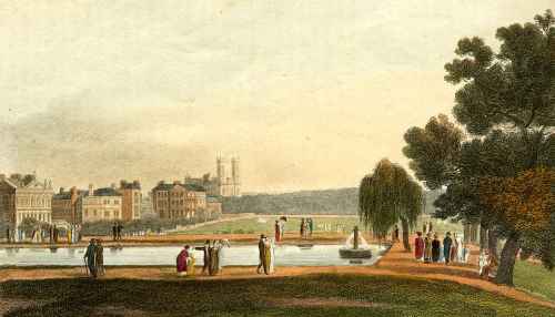
“No inhabitant of the metropolis, and scarcely any person who has visited it, needs to be told that the spot delineated in the annexed view [above] forms one of the most agreeable walks in London.” (Ackermann’s Repository October 1810).

This shows the eastern end of The Green Park (these days ‘The’ is always dropped) from Piccadilly, looking south. It seems the artist would have been somewhere between Clarges Street and Bolton Street. Westminster Abbey can be seen in the distance and on the left are the houses looking out onto the Queen’s Walk. St James’s Palace is hidden behind them at the far end. Nowadays Green Park tube station would be just out of sight on the left with the Ritz (on the site of The White Horse Cellar) just beyond that.

“In summer the eastern end of the Green Park forms a favourite promenade for the inhabitants of the metropolis: and in fine weather, on every evening and on Sundays in particular, is always extremely crowded with genteel and well dressed company. At the north-east corner of this park there is a fine piece of water, which is supplied by the water-works of Chelsea [The reservoir was built in 1775 and filled in in 1856] and forms at once a beautiful embellishment and a useful reservoir. The guards parade every day between ten and eleven o’clock, and a full band of music renders this spectacle cheerful and attractive.” (John Wallis London: Being a Complete Guide 1810)

Green Park is a triangular space of about 53 acres. To the south Constitution Hill divides it from the gardens of Buckingham Palace and St James’s Park butts up to it in the south-east corner with the Mall. In the 17th century it was part of St James’s Park, the Tudor hunting grounds, which swept around the south and west of the palace, but by the time of Roque’s map of 1738 the tree lined avenue of the Mall leading up to Buckingham House cut it off and it is labelled The Green Park. The gardens of Buckingham House were much smaller and the park crossed Constitution Hill, occupying the area that is now the large roundabout of Hyde Park Corner. The second print is from The Beauties of England & Wales Vol. 1 (1801) and shows the view west from the southern edge of the park towards Buckingham House which, by that time, had become The Queen’s Palace or House.

Green Park Q House

Before Henry VIII seized monastic properties St James’s Palace was the site of a religious foundation and a leper hospital and the legend persisted that Green Park was so green (and without flowers) because it was the burial place for the lepers. There is no evidence for this! Charles II was responsible for the park’s lay-out and Constitution Hill is thought to be named because it was a favourite walk, or ‘constitutional’ of his. He also built a snow, or ice, house and the mound can still be seen in the park opposite 119, Piccadilly.

The park, as well as being a fashionable promenade, was also popular for duels in the 18th century. Count Alfieri fought Lord Ligonier the husband of his mistress there and famously remarked (when he returned from the fight to finish watching the play at the Haymarket Theatre with a wounded arm) “My view is that Ligonier did not kill me because he did not want to, and I did not kill him because I did not know how.” The park was also an excellent location for balloon ascents and firework displays such as the 1814 Peace celebrations.

The gravel walk on the eastern boundary of the park is known as The Queen’s Walk and was created for Caroline, the wife of George II. She had a pavilion built for breakfasts looking out on the park, but no trace of it remains. The most distinguished house overlooking the Walk is Spencer House. It can be seen in the top print, identified by the roof ornaments, and in the print below. (1831  Earl Spencer’s House). It is open to the public  on Sundays (except in August) by bookable guided tours.

spencer


Save

Save

Save

Save

2 Comments

Filed under Architecture, High Society, London Parks, Royalty, St James's Park, Walks

1814 – the Summer of Celebrations

The summer of 1814 – and London is en fete to celebrate not only the victory over Napoleon but also the anniversary of Hanoverian rule. For three months Londoners had the opportunity to view, and enjoy, some of the most lavish celebrations the capital has ever seen.

Ack transp

On April 20 there was a triumphal procession for Louis XVII from Hyde Park to Grillon’s Hotel in Albemarle Street where he was staying with his entourage. On June 7 the Russian Czar Alexander I, King William III of Prussia, Marshal Blucher, Prince Metternich, the Prince of Liechtenstein, and Prince Leopold arrived in London and on June 11 the Prince Regent entertained all the Allied Leaders at the opera at Covent Garden. On June 16 they were the guests at a dinner held by the merchants and bankers of London in the City and on June 18 the Prince Regent, Marquess of Wellesley, Lord Liverpool, Marshal Blucher, Prince Metternich, Czar Alexander I, and Catherine Grand Duchess of Oldenburg were guests of honour at a dinner given by the Corporation of London.

On June 20, hopefully having had the opportunity for a rest and some digestion, the Prince Regent, the Duke of York, the King of Prussia, the Czar and  Generals Blucher, Lord Beresford and Hill reviewed 12,000 troops in Hyde Park. At 8pm that evening a re-enactment of the battle of Trafalgar was held in the park on the Serpentine with model ships three feet long (one metre) were deployed to recreate the main events of the battle. At the climax the French ships were sunk as the National Anthem was played.

The evening was staged as a popular entertainment and the park was transformed with stalls, arcades, and follies and pavilions. There were refreshments, taverns and fruit stalls and the crowd could listen to military bands as they watched acrobats or enjoyed the swings and roundabouts.

On June 22 the Allied Sovereigns watched a naval review at Portsmouth before leaving for the continent, but in London the celebrations were by no means over.

On June 28 Wellington was formally welcomed at Buckingham House by the Queen, and on July 1 a great ball was held in the Duke’s honour at Burlington House by White’s Club. It cost £10,000 and amongst the 1,700 guests was Jane Austen’s brother Henry. She was thrilled. On July 7 there was a Service of General Thanksgiving for the victory at St Paul’s Cathedral with Wellington carrying the Sword of State alongside the Regent and as a further sign of his pleasure the Regent held a fete in the gardens of Carlton House to honour the Duke on July 21.

Pagoda

August 1,1814 was the hundredth anniversary of the accession of George I of Hanover to the British throne. The Battle of the Nile was represented by rowing boats on the canal in St James’s Park which was crossed by a new ‘Chinese’ bridge with, in the centre, a seven-storey pagoda. According to Ackermann’s Repository “It appeared a blazing edifice of golden fire, every part being covered in lamps, and glass reflectors at proper intervals relieving the splendour with their silver lustre.” At the height of the fireworks the pagoda caught fire and two men and a number of swans perished, but the crowd thought it was part of the celebrations and cheered wildly.

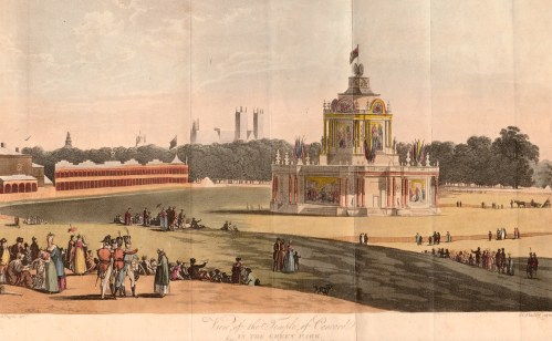
Meanwhile in Green Park a castle-like structure was built. After firework display that lasted, according to Ackermann’s, “for more than two hours, a discharge of cannon enveloped the whole building in smoke so dense, that no part of it was visible to the innumerable spectators assembled…but when this obstruction cleared away, it burst upon them, metamorphosed into the Temple of Concord, most brilliantly illuminated… and revolving upon its centre.”

Concord

Many shops and businesses also rose to the patriotic occasion and decorated their premises. Ackermann’s Repository at 101, Strand, was decorated by a ‘transparency’ almost 30 feet (10 metres) high and “brilliantly illuminated” from the back “with carbonic gas.”. The lower section shows the seven Christian and Cardinal Virtues with the Royal arms above and the standards of the Allied nations. The upper part is the Temple of Peace with the word REGENT above and all crowned with the Prince of Wales’s feathers. It is shown at the head of this post.

You can  enjoy these two historic parks by taking Walks 4 and 6 in Walking Jane Austen’s London.


Save

4 Comments

Filed under Architecture, Entertainment, London Parks, Prince Regent, Royalty, St James's Park, Wellington

Crossing the Knight’s Bridge

Today if you want to travel from the middle of London to visit the smart shops of Kensington and Chelsea, or the museums of South Kensington, or go to a concert at the Albert Hall, you will travel along Knightsbridge, the road that stretches for a mile from Hyde Park Corner to the east to the Royal Albert Hall in the west (becoming, these days, Kensington Road and the beginnings of Kensington Gore in the process). Are you in London? Of course you are.

When Jane Austen was staying with her brother Henry in his homes in Sloane Street and Hans Place, she was just as clear that Knightsbridge (or Knights Bridge, as it was known almost until the 19th century), was not London. ‘If the Weather permits, Eliza & I walk into London this morng.’ she wrote in April 1809 from 64, Sloane Street.

Roque 1741

(Above: Detail of Roque’s map of London 1741 showing Knight’s Bridge and the beginning of Kensington)

Although the tentacles of development were reaching out from the new Sloane Street, down the Brompton Road and along towards Kensington, London still began at the Hyde Park Turnpike, situated until 1825 just about where Grosvenor Place meets Knightsbridge today. Apsley House, which became the home of the Duke of Wellington, was the first dwelling you came to entering through the gates – Number One, London, in fact.

Knights Bridge was never a parish or a manor, only a locality, known from Saxon times as Kyngesburig, or Knightsbrigg. There are many legends about the origins of the name, but none appear to have any basis in fact. The bridge in question crossed the Westbourne River, one of London’s “lost rivers”, as it left Hyde Park, where it had been turned into the Serpentine. The Westbourne ran on south along a meandering course which marks the boundary of Chelsea and St George’s parishes to meet the Thames in the grounds of Chelsea Hospital. It was finally covered over in 1856/7 and became the unromantically-named Ranelagh Sewer and its outfall can still be seen at low tide. The Albert Gate of Hyde Park marks the point where it went under the road and William Street follows its line southwards.Hyde Park pike0001

If you had ventured this far in the time of the Tudors you would have encountered an appalling road, the “Waye to Reading”, mired so deep in mud that it contributed to the defeat of Sir Thomas Wyatt’s rebel army. They marched against Queen Mary, but arrived so exhausted by the state of the ‘road’ that they were easy prey for the royal troops. Things did not greatly improve for hundreds of years and even as late as 1842 reports were made of pavements ankle-deep in mud.

Worse than the mud were the highwaymen and footpads who infested this road. The last highway robbery on Knightsbridge was as late as 1799, after which a light horse patrol was sent out from the barracks to patrol the road and it was one of the earliest to have street lighting. Mr Davis in his “History of Knightsbridge” (1854) records that even after the armed patrols were instituted, “pedestrians walked to and from Kensington in bands sufficient to ensure mutual protection, starting their journey only at known intervals, of which a bell gave due warning.”

If we are feeling brave we can set out along this perilous mile, guided by the charming little map from Cecil Aldin’s The Romance of the Road (1928). East is at the top and we begin with the Hyde Park Corner tollgate and just before it, at the junction with Grosvenor Place, is St George’s Hospital. That is still there, but is now the Lanesborough Hotel. Behind it was Tattersall’s sale ring until it moved in 1865.

Aldin map 1

Going east we would have passed the White Hart Inn on the north side and a barracks for foot soldiers (demolished 1836) on the south. The narrow entrance to Old Barrack Yard still marks the spot. We cross the Westbourne as we pass William Street and can see today the unlovely round tower of the Sheraton Hotel. Once this was the site of a house owned by a Mr Lowndes and behind it, where Lowndes Square is now, was a rural pleasure garden, Spring Garden (not to be confused with the one of the same name next to what is now Trafalgar Square) at the sign of the “World’s End”. It is referred to in Pepys’s diaries several times, including in the final entry, May 31st 1669: “To the Park, Mary Botelier and a Dutch gentleman, a friend of hers being with us. Thence to the ‘World’s End’ a drinking house by the Park, and there merry, and so home late.”

(Below: Spring Gardens from a Victorian engraving of an earlier drawing.)

Spring Gardens

More or less opposite was Trinity Chapel which was probably medieval in origin and functioned as a hospital, or lazar house, for the poor. Traditionally it was said to have taken in plague victims in 1665 and the dead were buried opposite under Knightsbridge Green at the present junction of Knightsbridge, Sloane Street and Brompton Road. Eventually the chapel fell into total disrepair and was rebuilt. Its present incarnation is further along the road in Kensington.
For a long time before the passing of Lord Hardwicke’s Marriage Act in 1753 it was the location for irregular, clandestine or runaway marriages and the registers for the chapel contain entries with notes such as “secrecy for life” or “secret for fourteen years” added to them. Possibly the most famous person married there was Sir Robert Walpole who wed a daughter of the Lord Mayor of London. (The chapel is shown below in a view of part of the north side of Knightsbridge in 1820)

cahpel

Now we reach the Albert Gate into Hyde Park, the point where the Westbourne still runs under our feet. On the park side of the bridge was the Fox and Bull Inn (shown as the Fox on Aldin’s map), patronised by artists such as George Morland and Sir Joshua Reynolds, who painted its sign. Less pleasantly it was a receiving house for the Humane Society, founded to assist drowning persons, or deal with their bodies. It was to this inn that the body of Harriet Shelley, the poet’s first wife, was brought after she drowned herself in the Serpentine in 1816. Immediately after the Fox and Bull was the Cannon Brewery, so called from the cannon mounted on its roof. That was surrounded by “low and filthy courts with open cellars” – a far cry from the elegant Kuwaiti and French Embassy buildings which occupy the site now.

Almost opposite is the junction with Sloane Street, developed after 1780 along the old track from the King’s Road in Chelsea. Another old road, the Brompton Road, comes in at an angle at the same point and led to the village of Brompton and on to Fulham. At this junction was Knightsbridge Green with a watch house for the constable, a pound for straying livestock, and possibly the site of Trinity Chapel’s plague pit. This was the point where the granite sets that made up the road surface ceased and the mud really began. It is also close to this point that Tattersall’s moved in 1865.

Just past the brewery were the barracks for the Horse Guards, giving them direct access into Hyde Park, just as they have today. Originally built in 1794/5 the barracks were rebuilt in 1878/9 and then again in the 20th century, slightly further west on Knightsbridge. From here on there were virtually no buildings on the north side, only the brick wall of Hyde Park. The road now becomes Kensington Road.

On the south side of Knightsbridge, following the Brompton Road turning, were the Rose and Crown (the oldest of Knightsbridge’s inns, shown below) and the Old King’s Head and then the floor-cloth manufactory of Messrs. Smith and Barber. It had been established in 1754 and lasted well into the Victorian era.

Rose and Crown
Then came three mansions that were, when they were built, true “country houses”. The first was Rutland House, the next Kent House, home for a while of the Duke of Kent, Queen Victoria’s father, and then Kingston House. Kingston House was built in 1769 for the scandalous Elizabeth Chudleigh whose story is so amazing that I will save it for another post. She died in 1796 and it later became the home of the Marquis of Wellesley who died there in 1842. He was the elder brother of the Duke of Wellington.

Half Way House

An area of nursery gardens followed on the south side of the road, part of the great expanse of fruit and vegetable-producing land that surrounded London. Somewhere along this stretch we enter what is now known as Kensington Gore – nothing to do with blood, but named after Gore House which stood on the site of the Royal Albert Hall. It was built in the 1750s, decorated by Robert Adam and was the home in the 1780s of Admiral Lord Rodney. It was acquired in 1808 by William Wilberforce, the great campaigner for the abolition of the slave trade, who lived there until 1821.
Opposite Gore House, a most insalubrious neighbour for a fine mansion, was the Halfway House Inn (shown above). This was where the spies for the highwaymen of Hounslow Heath would congregate to see who was travelling and pass the word on to alert the highwaymen about fine carriages or vulnerable riders. Just beyond it on the park side was the first milestone from the Hyde Park turnpike, the point where we can leave the dangers of Knightsbridge behind us and enter the village of Kensington with a sigh of relief for our arrival safe from the mud and the footpads.

5 Comments

Filed under Buildings, Crime, High Society, London Parks

Londoners Take to Their Skates

Everyone has heard of the Thames Frost Fairs where the river froze solid and Londoners could walk across, drive across – and on one notable occasion in 1814, lead an elephant across. The first recorded frost fair was in 1608, the last in 1814, after which warmer winters changes in the river’s flow because of  alterations to the bridges prevented it ever being possible again. Below is a detail from Luke Clennel’s picture of that last fair.

Frost Fair

But the Thames did not freeze every year, even before 1814, and when it did the ice was covered in booths and stalls. More reliably Londoners could take to the frozen ponds and lakes in their parks and skate. Below is a detail from an original pen and ink sketch by George Morland in my own collection and you can see the simple skates laced onto the boots or shoes of the skaters.

Morland skaters crop

The Serpentine, the lake in Hyde Park formed from the Westbourne River, provided a particularly popular venue. The Picture of London for 1807, my favourite London guidebook describes it:

‘In severe winters, when the Serpentine River is frozen over, the ice is almost covered with people. One winter there were counted more than 6000 people at one time on the ice. A number of booths were pitched for the refreshment of the populace; and here and there was a group of six, eight or more, fashionable young men, skating, and describing very difficult figures, in the manner of a country dance, with particular neatness and facility of execution. In general, however, the English do not excel in this very exhilarating and wholesome exercise.
From the number of accidents which happen annually on this river when frozen over, his majesty gave the Humane Society a spot of ground on its banks on which they have erected a most convenient receiving-house for the recovery of the apparently drowned; it cost upwards of £500 and is worthy the inspection of the curious. The society, during the time of frost, keep men on the river to guard the unwary from danger, and to relieve those who may require their aid.’

The lake in St James’s Park was also a good size for skaters as this detail from an undated print shows. Some skaters are obviously far better than others!

St James Park

The building on the far bank is the Queen’s House – Buckingham House – which eventually became Buckingham Palace.

Finally here is the image I am using for my Christmas card this year. The lady in her gorgeously warm-looking crimson pelisse seems very snug as she watches the skaters, especially the gentleman with his frozen fingers tucked into his armpits! Her rather bizarre hat is decorated with holly and there is a full description of her outfit at the end of this post.

Walking dress crop

A Very Merry Christmas and Happy 2016 to all my readers!

A Winter Walking Dress from La Belle Assemblée Feb 1812

A scarlet Merino cloth pelisse, lined with straw coloured sarsnet, trimmed with light coloured spotted fur, and attached with loops of black silk cordon and rich frog tassels; the broad fur in front, forming a tippet, pointed at the back. A narrow fur passes from the top of the sleeve,
is brought down the side seams, and relieved by fastenings of black silk cordon; four loops with frog ornament the shoulders and cuffs; plain standing up collar tied with cordon: a fine cashmire (sic) shawl, with brown ground, and richly variegated border, is generally thrown over the dress, in which is united both comfort and elegance. A Swedish hat of the same materials as the pelisse, lined with straw colour, and fastened up on one side; the crown trimmed with two rows of narrow spotted fur, and one still narrower at the edge of the hat; a bunch of the Christmas holly in front, and two tassels falling from the summit of the crown, of black, to answer the pelisse, which is worn over a white round dress, either plain or corded cambric. Beaver gloves, and demi-broquins of scarlet Morocco,
laced with black, and lined with fur, complete the dress.

7 Comments

Filed under Christmas, Entertainment, Fashions, London Parks, St James's Park

Horse Guards Parade – Crocodiles, Cardinal Wolsey & Beach Volleyball

One of the emptiest, yet most evocative, spaces in London is Horse Guards Parade. In my last post I wrote about the Regent’s Bomb – the fantastical mortar and gun carriage that sits on one side of the Arch. This time I’m writing about a little of the history of the parade ground and another cannon with a wonderful gun carriage.Guardsman
Horse Guards Parade sits between Whitehall and St James’s Park and began life as open land next to the grounds of York Place, the London palace of the Archbishops of York. Its main entrance faced down the road that is now Horse Guards Avenue, the bishop’s route to his landing stage on the river. With the fall of Cardinal Wolsey Henry VIII seized York Place and then set about acquiring “…all the medowes about saynt James, and all the whole house of S.James and ther made a fayre manision and a parke…” according to Edward Hall.
When the king began his work on what was to become Whitehall Palace a willow marsh for the farming of osiers for basketwork, Steynour’s Croft, covered much of what is now Horse Guards, the Bell Inn stood at the southern edge and an old track crossed it from the scrubland that became St James’s Park.
By 1534 the Palace of Whitehall was largely complete. Part of the area, a longitudinal strip running west across Horse Guards became his tiltyard, scene of tournaments and knightly exercises. Under Elizabeth I the Tiltyard was used for animal baiting and tournaments and pageants which were set pieces for state occasions. Under James I elaborate masques were held – including one involving an elephant carrying a castle – but the increasingly theatrical nature of royal masques led to the building of the Banqueting House on the other side of what was then King Street (now Whitehall) and the last masque in the tiltyard was planned for 1624. After that it became known as the Bearstake Gallery and it continued to be used for baiting sports until 1660.
A standing guard was stationed in a specially built guardroom at the tiltyard from 1641 and the area continued to house soldiers throughout the Commonwealth period.
On May 8th 1660 Charles II was proclaimed on the site of the old Tiltyard ‘Green’ and the renovation of Whitehall Palace began. A plan of c1670 shows Whitehall as a wide street coming down from the north and ending at the pinch-point of a Tudor gate. The range of buildings that were the old Horse Guards were built in 1663 with a yard in front and behind the range the open expanse of ground that became Horse Guards Parade.
In January 1698 a great fire destroyed the Palace of Whitehall, sparing only the Banqueting Hall and Old Horse Guards. A letter of the time records, “All parts from near the house my Lord Lichfield lived in to the Horse Guards were yesterday covered with heaps of goods rescued from the flames.”
The king moved to St James’s Palace, across the park, and Whitehall became the location for many government offices and from the 1730s the buildings surrounding Horse Guards were gradually replaced. The dilapidated old building was demolished in 1750 and the new building – the one we see now – was designed by William Kent, with additions by Isaac Ware.


Horse Guards

The large open space was referred to as the Parade ground, but the first written reference to “Horse Guards Parade” as a title comes as late as 1817. By then the area looked much as it does today as can be seen in this print of 1809 by Rowlandson and Pugin, published by Ackermann. Only the high brick wall that closes off the gardens at the rear of Downing Street today (to the right of the picture) is missing.
The space is uncluttered now – when it is not being used for events such as Trooping the Colour and the Olympic Beach Volleyball, or in the Victorian era, the marshalling point for the vast funeral procession of the Duke of Wellington. However there are two interesting weapons exhibited there, either side of the arch. On one side is the Regent’s Bomb, on the other a 16th century Turkish cannon brought to the site in 1802 after its

capture in the siege of Alexandria (1801) when the British invaded Egypt to fight Napoleon’s army, an event that formed the setting for my recent novel Beguiled By

Her Betrayer.

DSCN0415

DSCN0413


It was made in 1526 and the inscription on the barrel reads:
“The Solomon of the age the Great Sultan Commander of the dragon guns When they breathe roaring like thunder. May the enemy’s forts be razed to the ground. Year of Hegira 931.”
The gun carriage was made at Woolwich and depicts Britannia pointing at the Pyramids and a rather splendid crocodile.                                                                     You can visit Horse Guards Parade both in my Walks Through Regency London (Walk 8 Trafalgar Square to Westminster, which follows the length of Whitehall)

and Walking Jane Austen’s London (Walk 6 Westminster to Charing Cross, which goes through St James’s Park).


Leave a comment

Filed under Buildings, London Parks, Monuments, St James's Park