Category Archives: Rivers

Living In History

I nearly always blog about the ‘long’ Regency, the era in which almost all my books are set, but like most of us who are passionate about history, any opportunity to get closer to it fires the imagination. One of the best ways of doing that is living in an historic building. Some people are lucky enough to own one, but for the rest of us the Landmark Trust provides brilliant opportunities to live in eras ranging from the Middle Ages to the mid 20th century.

This month I have stayed in three West County Landmarks – two castles (nothing says Social Distancing like a castle), one medieval and one Tudor, and a Listed mid-century house and I thought I’d share them with you.

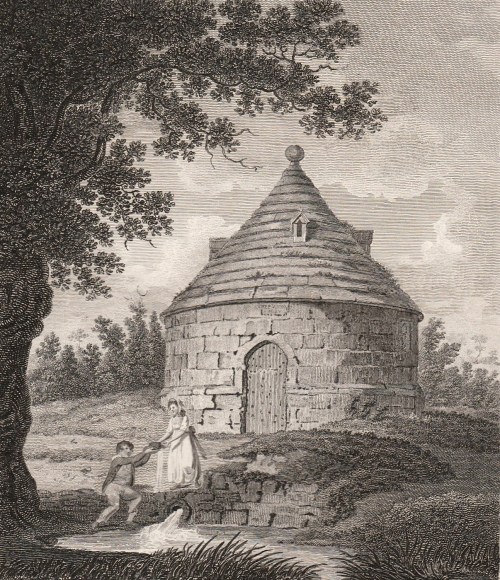
The first is Stogursey Castle near Bridgwater in Somerset, that just happened to be built by my husband’s distant great grandfather, William de Curci. Stoke de Curci was corrupted into Stogursey, hence the unusual name..

The castle itself is a ruin of curtain walls surrounding the central space where the keep used to stand.

The castle gradually fell into disrepair after the Wars of the Roses but the gatehouse, was  converted into a cottage in the 17th century. One side incorporates the base of a tower and the rest fits into the section where the gate itself would be. It was repaired in the 19th century and then fell into almost terminal decline until rescued by the Trust who discovered a bridge of about 1300 in the process.

We were enchanted to have a sitting room with arrow-slit windows.

The best view was just after sunrise and the only disappointment was that we couldn’t raise a drawbridge. Several walkers came and knocked, clearly under the impression that we could sell them tickets to get inside!

From Stogursey we went to Anderton House, near Barnstable, and couldn’t have found a greater contrast. The house was commissioned in 1969 and is one of the few houses of the period to have Grade II* Listed status.

The view was wonderful and we enjoyed the simple. pared-back design. In the centre, between the living room and kitchen/dining room was a small, open study space (the white wall behind the sofa), as specified by the original owner, who liked to work in the heart of things. I even managed to write a chapter there on a rainy day.

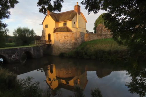
From our 20th century comforts we travelled on to the South Devon coast and Kingswear Castle, opposite Dartmouth Castle. Kingswear Castle was completed in 1502, a Tudor fortlet to defend a significant harbour.  The position is dramatic, the steps (inside and out) guarantee toned calf muscles by the end of the stay and the views are amazing. Here’s the castle from the opposite bank –

And here is the view across the River Dart to Dartmouth Castle in the early morning.

Stogursey Castle gave me the opportunity to soak up general atmosphere but Kingswear has far more practical experiences. The castle was, when it was built, absolutely state of the art. It possessed the first gun ports that allowed cannon to be trained in a wide sweep of fire and these gun ports remain on the lowest level in the gun battery (picture below). They are low in the walls because the guns were on wooden sledges, not on wheels, and were dragged into position. Above some of them you can see the small apertures that may have been sighting holes for the gunners. Even with the primitive cannon of the time the pair of forts between them could cover the width of the river.

Then artillery design improved and the range rapidly increased to the point where Dartmouth Castle alone could fire right across the estuary and Kingswear became more or less redundant after fifty years. It was manned during times of emergency and saw some action during the Civil War, but then there was a fire and it was allowed to fall into decay. In 1855 a wealthy young man, Charles Hayne Seale Hayne (yes, that is the correct name), bought it and turned it into his summer residence. He later became an MP and held office in Gladstone’s government. After his death it had several owners, was occupied by the Marines during the 2nd World War and was rescued again in 1957 by the MP for Torquay as his constituency home. In 1987 he sold it to the Landmark Trust.

Living in the castle now, one has the benefit of a modern kitchen and comfortable sitting room and bedroom, but there are constant reminders of the original purpose of the castle. There is modern plumbing in a bathroom on the roof, in the position where a firing platform would have allowed defenders to shoot at attackers on the landward side – the slope is so steep that the top of the castle is virtually at the level where today one parks the car. This meant that I could conveniently arrange the contents of my washbag in the sockets that carried the beams supporting the platform and could brush my teeth imagining the gunfire and shouts echoing overhead.

The position of the bathroom meant that one had regular experience of living with a stone spiral staircase spanning four floors. It was tough enough in modern clothing and not carrying anything, but negotiating it at night gave me a vivid sense of what it must have been like for defenders, probably in some kind of armour or chainmail, hurrying up and down during an attack. [The image below has been copied from the Landmark Trust website] It also made me wish that the Landmark Trust had seen fit to reinstall the garderobe which was discovered in the alcove that Seale Hayne had used as a wine cupboard and into which a later occupant had installed a large window. It is now in the bedroom.


Finally, to top off Kingswear’s historical experience, there is the 2nd World War blockhouse.

I look back on ten days experience of the Middle Ages, the early 16thc, the English Civil War, the 2nd World War and the 1970s with my imagination stimulated and ideas jostling for attention – and of course, in expeditions out from our Landmarks I discovered treasures that fitted ‘my’ period perfectly – a very early steam engine and a delicious little Regency ‘Gothic’ house in Totnes, which is surely going to have a place in a future book.


2 Comments

Filed under Architecture, Buildings, Domestic life, Military, Rivers

Perambulations Through Late Georgian London or, All the Best Sights in One Week. Day Six

It is Saturday and we have reached day six in the action-packed itinerary recommended by Mr Herriott in his 1836 Modern Picture of London. Today’s expedition involves a river trip and seems slightly less exhausting, despite an early start.

Visit Covent Garden Market, before breakfast;

Covent Garden market has been in operation since 1656 and has always attracted visitors  – not always in search of fresh fruit and veg or hedgehogs to keep the slugs off their own gardens. In the heart of theatre-land it had a reputation for prostitution and wild nightlife but Mr Herriot was probably safe in sending his tourists there first thing in the morning to view the bustle of porters and shoppers.

The market today is the result of several campaigns of building work and the 1836 visitors would have seen the new market halls shown in this print from Thomas H Shepherd’s Metropolitan Improvements. In this view the east façade of St Paul’s church is to the left of us. The new building cost £70,000 and, according to The Gardener’s Magazine, was “a structure at once perfectly fitted for its various uses; of great architectural beauty and elegance; and so expressive of the purposes for which it is erected, that it cannot by any possibility be mistaken for anything but what it is.” Unfortunately only twenty five years later it was already inadequate and many more alterations have been made.

Return,

Presumably breakfast will be taken before the visitors

go over Hungerford Market,

This was on the site of what is now Charing Cross station. It was built in 1682 as a rival to Covent Garden and was rebuilt as a two-storey market for meat, fish, fruit and vegetables in 1833. The image is from 1850 and shows the view of the market from Hungerford Bridge, built 1841 by Brunel (and replaced by the present eyesore of a structure in 1864).

take a boat at the stairs, to Chelsea.

Before the bridge was built there was a landing stage for passenger boats in front of the market.

See Westminster Bridge, the Speaker’s House,

It must have been very restful, after all the walking over the previous days, to float upriver. The print shows St Stephen’s Chapel and the Speaker’s House from Westminster Bridge. (Ackermann’s Repository, 1815)

the Penitentiary,

Millbank Penitentiary was built on the site of what is now the Tate Gallery and was completed in 1821. It took male and female prisoners who previously would have been transported to New South Wales, but that was becoming overcrowded and the cost was high. It was originally intended to be a humane institution, according to the principles of Jeremy Bentham. Prisoners were to be constantly under the view of guards from a central ‘Panopticon’ and were expected to work in silence and isolation so they could reflect on their sins and on the virtues of honest toil. The reality was an inhumane nightmare. Prisoners were driven insane by the isolation and the site was so marshy and unhealthy that scurvy and cholera swept through the building. By the 1830s conditions had improved somewhat – candles were put in the cells and some education and recreation was provided while sanitary conditions were upgraded. It was finally closed in 1890.

 Vauxhall Bridge

The view is from the bank just upstream of the Penitentiary. This bridge was the first iron bridge over the Thames and was opened in 1816. It was replaced with the current bridge in 1906.

the Royal Hospital, at Chelsea.

The Royal Hospital is better known as Chelsea Hospital, home of the Chelsea Pensioners. It was founded in 1692 by Charles II to provide a home for veteran soldiers and has been fulfilling that function ever since.

David Wilkie’s 1822 picture of Chelsea Pensioners reading the news of Waterloo shows the Royal Hospital in the background

Walk to the Duke of York’s School

The Duke of York’s Royal Military School was founded by ‘the Grand Old Duke’ whose house the visitors passed on Friday’s expedition. It was a pioneering effort to help the previously neglected families of the common soldiers by providing education for fatherless children. A history of the school states that, “From its inception, the Asylum provided the country with the first large scale system of education of working class children.”

The building is now occupied by the Saatchi Gallery.

thence to the Pantechnicon, through Belgrave Square.

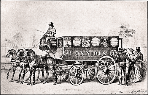
I imagine the visitors would take a cab to this large emporium, covering two acres, in Motcomb Street. It was opened in 1834 and sold carriages and household furniture. It was destroyed by fire in 1874 but the façade remains.


Ride home, and in the evening go to the Opera House.

This is presumably the Italian Opera House at the junction of Pall Mall and Haymarket. It has been variously known as the Queen’s, the King’s, Her Majesty’s, His Majesty’s, or the Opera House. Her Majesty’s Theatre currently occupies about half the area of the Italian Opera House shown in this print. The building shown was built in 1790/1 on the site of Sir John Vanburgh’s theatre of 1704. The facades on three sides were added by Nash and Repton in 1816-18. The present theatre dates to  1897.

The interior was redecorated in 1814, not very well, as this extract The Times of 16 January 1815 describes. “Last night this Theatre opened for the season. From the squalid and disarranged state in which it closed, great room as well as great necessity for improvement and cleaning were left to the new Manager [Waters], and certainly much less has been done to restore it to its rank among decent places of public resort. The fronts of the boxes have all been newly coloured. . . . The cieling [sic] represents the Genius of Music, with Iris, and some nondescript figures encircling him. . . . The former cieling [sic] was a striking and vigorous representation. The present must convey to a stranger the impression, either that the arts in England were at the lowest imaginable ebb, or that the arts had nothing to do with this Theatre. . . . The chandeliers are numerous and rich, and the effect as dazzling as anything to be found within the magic of chandeliers. . . . The adoption of glass bells or shades would be devoutly wished for. . . . Last night they poured down their wax on the beaux in the most unsparing profusion; and from their situation over the principal avenues of the Pit, have means of annoyance clearly unrivalled by the noxie [sic] of any of the metropolitan theatres.”

To quote The Survey of London (1960), things improved. “The interior was redecorated under Nash and Repton’s direction, and new lighting was installed, a splendid gas-lit lustre suspended from the domed ceiling replacing the many chandeliers that hung from the tier fronts. An early-Victorian booking plan shows that the auditorium then contained 145 boxes, besides 32 smaller boxes in the arms of the top tier. There were eight rows of stalls, with 222 seats; a pit with fourteen rows of benches; and four rows of gallery stalls, with 112 seats.”

Tomorrow is Sunday, so our valiant tourists can look forward to a day of gentle exercise for the body and some uplifting church services to round off their week.

1 Comment

Filed under Architecture, Buildings, Entertainment, Monuments, Rivers, Shopping, Walks

Perambulations Through Late Georgian London or, All the Best Sights in One Week. Day Four

It’s Thursday, the fourth day of the London sightseeing programme proposed by Nathaniel Whittock in 1836. By now the tourists are either on their knees with exhaustion or getting their second wind after the itineraries described in my previous three posts. They might be relieved to find that there is a fair amount of riding around involved in today’s expedition. This itinerary illustrates more clearly than any of the others how close to the Victorian era these visitors are as they experience engineering marvels and improvements in public transport.

Get into the omnibus or coach that goes to Blackwall.

Mr Whittock informs us that “Omnibusses [sic] now run through the leading thoroughfares: their charge is generally stated on the outside of the carriage. At the present time it is as cheap as the most rigid economist could desire as a person may ride in a handsome vehicle from the Bank to Paddington, a distance of four miles, for sixpence.”

George Shillibeer brought horse-drawn omnibuses (shown in the print above) to London in 1829, having seen them operating in Paris. At first they operated with a conductor who took the fares but did not issue tickets. He recorded all the transactions on a waybill, then paid his own, and the driver’s, wages from the money collected and handed the rest over to the bus owner.

An account of the new service was given in the Morning Post of 7 July 1829. “Saturday the new vehicle, called the Omnibus, commenced running from Paddington to the City, and excited considerable notice, both from the novel form of the carriage, and the elegance with which it is fitted out. It is capable of accommodating 16 or 18 persons, all inside, and we apprehend it would be almost impossible to make it overturn, owing to the great width of the carriage. It was drawn by three beautiful bays abreast, after the French fashion. The Omnibus is a handsome machine, in the shape of a van. The width the horses occupy will render the vehicle rather inconvenient to be turned or driven through some of the streets of London.”

see the East and West India Docks


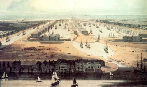
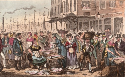
The London docks must have been a spectacular sight, teeming with a mass of sailing ships from all parts of the world. The print is a detail from a painting of 1802, looking west across the neck of the Isle of Dogs towards the City, and showing the West India Dock, opened that year. The import dock is on the right, the dock on the left is for export. The canal on the left later became the South Dock. The East India Docks were slightly to the east at the top of the northward bend of the Blackwall Reach of the Thames. Surrounding the docks were huge secure warehouses with walls thirty feet high and their own guards, an effective protection against the menace of ‘limpers’, ‘water pads’ and ‘water sneaks’ who preyed on the craft moored in the river itself.

The map shows the docks in 1849.

A short walk thence will take you to the Ferry-House. On crossing the Thames, see Greenwich Hospital.

These days an entire day can easily be spent in Greenwich but Mr Whittock merely invites his readers to admire the exterior of the buildings (he doesn’t even mention the Queen’s House), enter the Great Hall and look up the hill to the Observatory – ‘a conspicuous and celebrated Object.’

Ride on the Railroad as far as Bermondsey;

This would have been a real highlight for visitors – the first railway line in London. It was intended only for passengers and was built from London Bridge to Greenwich on a viaduct twenty two feet above the ground and supported on “nearly a thousand arches…intended to be converted into dwelling-houses or places of business.” It cut the journey time from London Bridge to Greenwich from an hour to ten minutes and was the forerunner of all the London commuter lines.

 walk to Rotherhithe, devote an hour to the examination of the Tunnel.

Interestingly, Mr Whittock seems more excited about the Thames Tunnel than he does about the railway. It was certainly an epic piece of engineering, during the course of which Marc Brunel (father of Isambard Kingdom Brunel) invented the tunnel shield which is the basis of all tunnel-boring today. Made essential by the development of the docks, and the problems of building bridges over the Thames to bring the workers from south of the river, it was intended for carriage traffic but instead became a footway and a major tourist attraction. It was converted to take the East London railway line in 1869. The print is from 1835.

Dine at Rotherhithe, and afterwards ride to the Surrey Zoological Gardens.

The Surrey Zoological Society Gardens were founded in 1831 and occupied a site now under Penton Place in Walworth, just north-east of the Oval cricket ground. Impressario Edward Cross sold them the contents of his menagerie at Exeter Change which I blogged about here. It must have been some improvement for the animals who were housed in cages under a circular domed glass conservatory 300 feet (90 m) in circumference. There were lions, tigers, a rhinoceros and giraffes (shown here in 1841) and, for a time, the gardens were more popular than London Zoo in Regent’s Park. However, that was subsidised, and cheaper (the Surrey Gardens cost one shilling admission), so gained in popularity. The gardens, which were lavishly planted and dotted with pavilions, were used for large public entertainments from 1837 – re-enactments of the eruption of Mount Vesuvius, the Great Fire of London, or the storming of Badajoz – and spectacular firework displays. The Great Exhibition of 1851 was the final nail in its coffin and it closed in 1856.

Towards the evening return to dress, and at eight o’clock go by water to Vauxhall.

Vauxhall Gardens lay where the modern park is still situated, close to the Thames and Vauxhall Bridge. Going by water was the traditional way of visiting, even though the first bridge had opened in 1816.

I have blogged about Vauxhall Pleasure Gardens here and also in comparison with their rival, Ranelagh. The print by Cruickshank shows the Gardens in the 1830s, just as our tourists must have seen them.

They would have staggered back to their lodgings late and perhaps a trifle tipsy. Hopefully they get a decent night’s sleep, because Friday will be devoted to the West End, London Zoo, shopping and the theatre.

If you are interested in more of the slang used for London’s criminal classes, including the river thieves, you can find that, and much more, here

1 Comment

Filed under Animals, Architecture, Buildings, Crime, Entertainment, London Parks, Rivers, Science & technology, Transport and travel

Just A Dip in the Street? One of London’s Lost Rivers

Last week, on a visit to London, I got off a bus on Ludgate Hill, walked down to Ludgate Circus and turned left down New Bridge Street towards the Thames, ignoring Fleet Street rising up straight ahead. It is something that workers and tourists do in their thousands every day of the week, but I wonder how many of us think about why there is such a steep hill and dip in the street just there. The clue is in Fleet Street and the valley was, of course, caused by the River Fleet, now flowing under New Bridge Street in the guise of a sewer to its virtually invisible outfall in the Thames.

The map below is a section of Cary’s New Plan of London (1784)

Blackfriars

Travelling about London one tends not to notice its dips and hills. I have posted in the past about taking the 23 bus and experiencing the dip not only of the Fleet but also the Tyburn Brook in Oxford Street. On the map above the streets with ‘hill’ names help us map the course of the Fleet. At the top of Fleet Market, formed when the river was covered over in 1733, Holborn Hill and Snow Hill dip down from west and east and the course of the river continues northwards under Saffron Hill.

New Bridge Streetfull size

The image above is from Ackermann’s Repository May 1812, “from a drawing by that eminent artist in water-colour painting, Mr Frederick Nash.” The artist shows the scene as though he is standing in the middle of Ludgate Circus (although the maps of the time do not give the junction a specific name). The bump of Blackfriars Bridge is just visible in the far distance, Fleet Street is to the right and Ludgate Hill to the left.

“The obelisk at the north end of this street, as shewn in the view, was erected to give safety to the public crossing, in the year 1775, during the mayoralty of the celebrated John Wilkes.” (Wilkes (1725 – 1797) was a  radical, journalist, libertine and Member of Parliament. He was also an enthusiastic supporter of American independence although he grew increasingly conservative with age.) The obelisk has long gone, unfortunately.

The Fleet rises on Hampstead Heath, as does the Tyburn, but there is no trace these days other than the three swimming ponds on the Heath. In the Middle Ages it was still navigable by barges as far as Holborn Bridge, to the north of the section in this map of 1563. Fleet Bridge is named and below it was the Bridewell Bridge , “said to resemble to Rialto at Venice” according to Ackermann’s – it  certainly seems to be covered. Before the Great Fire it was made of wood, but was replaced in stone with two arches.

Blackfriars 1563

Bridewell, which has now vanished, began as a palace and rapidly deteriorated into a prison. I traced its history here.

In 1733 the length between the Holborn and Ludgate bridges was covered and became Fleet Market – the double row of stalls can be seen in Roque’s map of 1738/47 (below). The Fleet Prison shows clearly, middle top, – the curve of the wall is still reflected in the building line today.

Below Fleet Bridge the  Bridewell Bridge has disappeared and the Fleet itself is labelled ‘Fleet Ditch’, an apt name by then – it was a stinking mass of refuse. Pope in his Dunciad writes of it:

Fleet Ditch, with disemboguing streams,

Rolls the large tribute of dead dogs to Thames;

The King of Dykes! than whom no sluice of mud,

With deeper sable blots the silver flow.

Or, to quote Ackermann’s rather more prosaic description, “…in the state of a muddy and loathsome ditch, until the building of Blackfriars-Bridge in the year 1768. In the place of this ditch, which had become a serious public nuisance, has sprung up the noble street, exhibited in this view [ie the print above], called New Bridge-street.”

Blackfriars Roque

The original Blackfriars Bridge was begun in 1760 and was finally completed in 1769, although it was open to pedestrians in 1766 and to riders in 1768. It was intended to name it for the Prime Minister, William Pitt, as the remaining inscription still confusingly explains, but popular usage soon had it named for the area, the site of the old Black Friars’ monastery. Repairs took place in 1832, but the bridge deteriorated to such an extent that a new one was proposed. It took years, the building of the Thames Embankment and the demands of the railways, but in 1869 and new bridge was opened. (The parallel railway bridge, just downstream, opened in 1864).

After exploring the area, the marvellous Art Nouveau Blackfriar pub just before the bridge is an excellent place to have lunch and to admire the depiction of the monks who once inhabited the area. (Get there early – it is very popular!)


Leave a comment

Filed under Architecture, Buildings, Maps, Rivers, Transport and travel, Walks

Admiring the Adelphi

In the 1750s the three acre site between the Strand and the Thames that had once been occupied by Durham House was nothing more than a ruinous network of slum courts. It was to be transformed into the Adelphi (from the Greek for brothers), an elegant housing development, by the family of Scottish architects John, William, Robert and James Adam. They leased the land for 99 years and imported a large team of bagpipe-playing Scottish labourers – cheaper apparently than the local workmen and a source of considerable resentment. (although the unfamiliar bagpipes may have contributed to that).

The Thames was not embanked at that point and the land simply ran down to the muddy foreshore with landing stages and water gates. It required an Act of Parliament in 1771 to allow the Adam brothers to create an embankment with arched entrances into subterranean streets and storage areas and the Corporation of London was none too pleased at this infringement of its rights over the river. As well as the Mayor and Corporation they also managed to upset the Watermen and Lightermen’s Company, the Coal and Corn Lightermen and (somehow) the Dean and Chapter of Westminster Abbey. A popular ditty of the time reveals the general prejudice against the oatmeal-eating Scots.

Four Scotsmen by the name of Adams

Who keep their coaches and their madams,

Quoth John in sulky mood to Thomas

Have stole the very river from us.

O Scotland, long has it been said

Their teeth are sharp for English bread

What seize our bread and water too….

Take all to gratify your pride

But dip your oatmeal in the Clyde.

The Adams brother might have got the site at a good price but they soon found themselves in financial difficulties as they constructed the magnificent terrace of eleven houses which made up Adelphi Terrace shown in the print at the top of the post. They had employed top-level craftsmen and artists on the interiors, including painter Angelica Kaufman. Then, no sooner had they begun than there was a spectacular banking crash “the Panic” of 1772  following the collapse of the Ayr Bank. The repercussions were far-reaching and had an effect in both Europe and America. Faced with bankruptcy they held a lottery in 1774 which cleared their debts (probably helped by the fact that, somehow, they managed to win the main prize themselves.) Their next scheme, Portland Place in Marylebone, built between 1776 and 1790, created further financial problems and with house prices in the Capital falling they found it hard to sell the Adelphi properties and cover their costs with prices falling from £1,000 to just over £300 between 1773 and 1779.

However, they persevered and, with the help of royal favour and celebrity endorsement (David Garrick the star of the stage was a friend and the artist Rowlandson lived there for many years) they went on to sell to a number of big names. Behind the Adelphi Terrace itself was a tight set of streets named after the brothers themselves, along with shops and apartments and the Royal Society of Arts (Below. John Adam Street).

Only a few of the original houses now remain and the fabulous Adelphi Terrace was demolished in 1938 and rebuilt. John Street and Duke Street are now John Adam Street and William Street is Durham House Street.

The vaults under the Terrace still partly exist and can be glimpsed from Lower Robert Street, off York Buildings.

The final print shows the Terrace in the early 19th century. On the left, the little building is the York Watergate, built in 1626 for the Duke of Buckingham to act as a smart entrance to a private landing and steps. It has now been placed in the Victoria Embankment Gardens, completely out of context.

Save

Save

Save

Save

Save

Save

Save

Save

Save

Save

Save

Save

Save

Save

Save

Save

Save

3 Comments

Filed under Architecture, Buildings, Rivers

A Fishy Business – Billingsgate Market

The New Family Cookery or Town and Country Housekeepers’ Guide by Duncan MacDonald (1812) begins its General Directions for Marketing with fish and with Billingsgate Market:

The comment in the penultimate paragraph is ironic, considering Billingsgate’s colourful reputation! When I was researching for my book Regency Slang Revealed I discovered that to talk Billingsgate meant to use particularly coarse and foul language.

Billingsgate Market was sited at the foot of Lower Thames Street from at least the 10th century until it was moved to the new market site on the Isle of Dogs in 1982. The first set of toll regulations covering it dates from 1016 and by the time of Elizabeth I it was dealing in corn, malt, salt and vegetables, although fish was always the main reason for its existence at the highest point where fish could be unloaded straight from the boats before London Bridge. It can be seen in Horwood’s map of London (c1800) below with the deep indentation of the dock taking a bite out of the waterfront and London Bridge on the left. This dock vanished with the Victorian rebuilding of the market in 1850. That building proved inadequate and was replaced with the present handsome structure by Sir Horace Jones, opened in 1877. It was refurbished after the closure and is now used for various commercial purposes. During the 1988 work extensive remains of the late 12th century/early 13th century waterfront were revealed.

The engraving from a print of 1820 shows the view of the dock from the river. At this date there was no covered market building, simply stalls and tables set out around the dock. In the days before a ready supply of ice dealers would come into Billingsgate from places within about twenty five miles – an outer ring that included Windsor, St Albans and Romford – and fish was sold in lots by the Dutch auction method where the price falls until a buyer is found. 
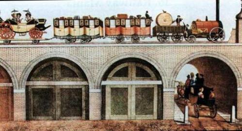
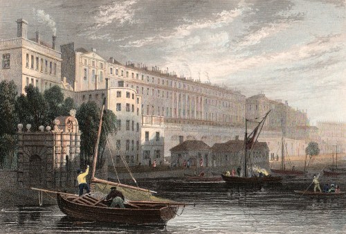
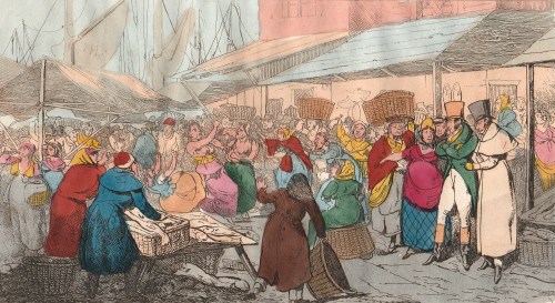
Many of the fish were caught in the Thames and in 1828 a Parliamentary Committee took evidence that in 1798 there were 400 fishermen, each owning a boat and employing one boy, who made a good living between Deptford and London catching roach, plaice, smelts, flounders, shad, eels, dudgeon, dace and dabs. One witness stated that in 1810 3,000 Thames salmon were landed in the season. By the time of the Commission,eighteen years later, the fishery had been destroyed by the massive pollution of the river from water closets and  the waste from gas works and factories that went straight into the river.

It was the fishwives of Billingsgate who became its most notorious feature. They were tough women, as they needed to be to thrive in such a hard, competitive business, and they did not shrink from either physical violence or colourful language. In Bailey’s English Dictionary (1736) a “Billingsgate” is defined as “a scolding, impudent slut.” Addison referred to the “debate” that arose among “the ladies of the British fishery” and Ned Ward describes them scolding and chattering among their heaps of fish, “ready enough to knock down the auctioneer who did not knock down a lot to them.”

The women of Billingsgate were an inevitable attraction to young bucks and gentlemen slumming, as the two prints below show. The top one is a drawing by Henry Alken for the Tom and Jerry series – “Billingsgate: Tom and Bob taking a Survey after a Night’s Spree.”  Below that is “A Frolic: High Life or a Visit to Billingsgate” from The London Spy.

Here two sporting gentlemen stand out in the crowd of working people as they watch a fight that has broken out between two bare-breasted fishwives. Another has just been knocked to the ground. Amongst the details note the woman sitting on a basket smoking a clay pipe, another (far left) taking a swig from a bottle and the porter’s hat on the man in the centre foreground with its long ‘skirt’ to protect the neck.

This print below is not dated, but as there is the funnel of a steam boat in the background amongst the masts it is probably 1820s.

Here a determined-looking lady in a riding habit, her veil thrown back and her whip under her arm, is negotiating the sale of a large fish head. Behind her is a smartly-dressed woman, perhaps a merchant’s wife, and an elderly gentleman in spectacles is talking to another fish seller on the far right. There are two men in livery, perhaps accompanying the lady in the riding habit. The man standing behind the seated fishwife is a sailor, judging by his tarred pigtail, and the porter walking towards us is wearing one of the black hats whose ‘tail’ can just be glimpsed over his shoulders. It is all fairly orderly and respectable, despite the crowd (and the smell, no doubt) but a hint to the other activities in the area may be the couple in the window!


Save

Save

Save

Save

Save

Save

Save

Save

Save

1 Comment

Filed under Buildings, Food & drink, Rivers, Shopping, Street life, Women, working life

From Palace to Prison – a Short History of Bridewell

prospect-of-bridewell

How does somewhere turn, in the space of thirty years, from a royal palace where the Holy Roman Emperor Charles V was lavishly entertained to a place whose name became generic for prisons for the punishment of vagrants and fallen women?

Bridewell Palace was built for Henry VIII between 1515 and 1520. Its southern façade faced the Thames, its eastern face was on the banks of the River Fleet and it was named for the nearby holy well of St Bride and it was a typical rambling, brick-built Tudor palace around three courtyards. It was the location where Hans Holbein’s famous painting The Ambassadors was set, the venue for masques and celebrations when Charles V visited and the home of Henry’s illegitimate son Henry Blount, Duke of Richmond and Somerset.

Its days as a palace were short-lived after it served as the venue for conferences with the Papal Legate over the royal divorce and Henry’s last meeting with Catherine of Aragon in November 1529. By 1531 it was leased to the French Ambassador and it was there in 1533 that Holbein’s The Ambassadors was painted.

In 1553 Edward VI gave Bridewell away, granting it to the City of London as a home for destitute children and vagrants and as a prison for punishing disorderly and loose women and petty offenders with short periods of incarceration and regular whippings. Queen Mary confirmed Edward’s gift – perhaps not wanting to take back the place of such ill-memories of her mother.

The model of prison, hospital and workrooms proved successful enough for many others to be opened across the country, all called Bridewells. The whippings took place in  public twice a week, there was a ducking stool on the banks of the Thames in 1628 and there were also stocks. The regime appears to have been one of “short, sharp shock”, although it seems doubtful that it was very successful in reducing vagrancy, petty crime and immoral behaviour with no support for its inhabitants once they were released. More fortunate were orphans of City Freemen who were accommodated here for an education before being apprenticed to a trade.

The Great Fire of 1666 destroyed much of the old palace and it was rebuilt in 1667. Judging by the print at the top of this post from a drawing by Jan Kip made in the early 18th century, some of the old Tudor palace survived. It can be seen surrounding the courtyard in the foreground with the 17th century and later additions behind. This version of Kip’s drawing was published in 1720 by John Strype and shows the view from the east – in other words, the artist is hovering above the Fleet River and looking west. The two courtyards of the rebuilt Bridewell can be clearly seen in this detail from John Rocque’s map of 1747 (below) turned to be in the same orientation.

bridewell-roque

Despite the floggings the Bridewell was more liberal than other prisons of the time – it had a doctor in 1700, seventy five years before they were appointed to prisons elsewhere, and in 1788 prisoners were not only given straw for their beds but actual beds to put it in – other gaols had neither beds nor straw. Women were not whipped after 1791. The air quality must have improved somewhat after the Fleet was covered in 1764 with the creation of New Bridge Street down to Blackfriars Bridge (1760-69).

The beds filled with straw can be seen in this print of The Pass-Room at Bridewell, 1808 from Ackermann’s Microcosm of London. Here single women with babies were locked up as punishment for their ‘loose behaviour’. The notice on the wall warns that “Those who dirts Their Bed will be Punished.”

bridewell

Building work and improvements carried on until 1833 when all the Bridewells passed from local control to become part of the government’s prison system. In 1855 the prisoners were transferred to Holloway prison and the buildings were demolished in 1863/4. The only remaining fragment is the façade and gateway of 1802 which is now 14, New Bridge Street.

The outline of the site remains in the block bounded by New Bridge Street to the east, Tudor Street to the south, and Bridewell Place which wraps around the west and north sides. Tudor Street can be seen on the Rocque map and led towards one of the notorious and lawless Alsatias from which many of the inmates of Bridewell probably came.

As with Bedlam, the public could gain admittance to view the unfortunate inmates. Priscilla Wakefield, author of Perambulations in London (1814) wrote, ‘Many of the prisoners who we were permitted to see, were women, young, beautiful and depraved.’ Like much of Wakefield’s moralising writing this fills me with the desire to give her the life-chances those ‘depraved’ young women had and see how she got on!

The print below is from Ackermann’s Repository of May 1812 and shows the view looking south down New Bridge Street from what is now Ludgate Circus where Fleet Street dips down to the Fleet Valley and then rises eastwards up Ludgate Hill to St Paul’s Cathedral. Bridewell is concealed behind the furthest range of brown buildings on the right of the print.

new-bridge-street

This area is included in Walk 8 of my Walking Jane Austen’s London and Walk 9 of Walks Through Regency London.


Save

Save

Save

7 Comments

Filed under Architecture, Buildings, Crime, Rivers

The Rural Beauties of Bayswater – a completely unrecognisable London scene

bayswater

This is a “View of the Conduit at Bays-Water” (1796) To find the location of this beautiful rural scene today  go to Leinster Terrace, about halfway between the Lancaster Gate and Queensway tube stations on the Bayswater Road on the northern edge of Hyde Park. Walk north for about 150 metres to Craven Hill Gardens and there you are.  Have a look on Streetview and you’ll see that you are in the middle of respectable early Victorian houses and shops because, until about 1839, this was open country.

Bayswater was well known for its springs and the name is said to originate in the principal one, Baynard’s Watering, known from the earliest Middle Ages. From 1439 until 1812 the Bayswater Conduit carried water from Baynard’s Watering to supply the City of London and the area around was one of London’s beauty spots. It really needs some imagination to conjure up what lies beneath the pavements!


Save

Leave a comment

Filed under Architecture, Buildings, Rivers