Tag Archives: New Bridge Street

Just A Dip in the Street? One of London’s Lost Rivers

Last week, on a visit to London, I got off a bus on Ludgate Hill, walked down to Ludgate Circus and turned left down New Bridge Street towards the Thames, ignoring Fleet Street rising up straight ahead. It is something that workers and tourists do in their thousands every day of the week, but I wonder how many of us think about why there is such a steep hill and dip in the street just there. The clue is in Fleet Street and the valley was, of course, caused by the River Fleet, now flowing under New Bridge Street in the guise of a sewer to its virtually invisible outfall in the Thames.

The map below is a section of Cary’s New Plan of London (1784)

Blackfriars

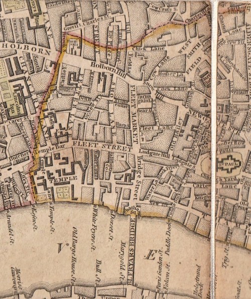
Travelling about London one tends not to notice its dips and hills. I have posted in the past about taking the 23 bus and experiencing the dip not only of the Fleet but also the Tyburn Brook in Oxford Street. On the map above the streets with ‘hill’ names help us map the course of the Fleet. At the top of Fleet Market, formed when the river was covered over in 1733, Holborn Hill and Snow Hill dip down from west and east and the course of the river continues northwards under Saffron Hill.

New Bridge Streetfull size

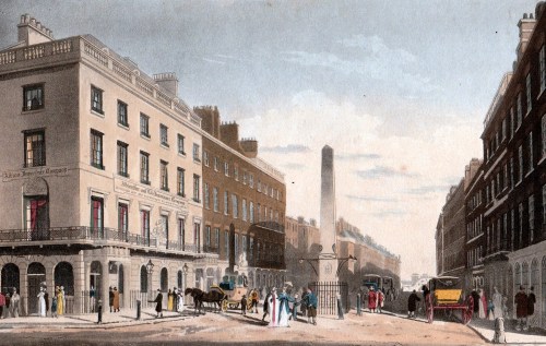
The image above is from Ackermann’s Repository May 1812, “from a drawing by that eminent artist in water-colour painting, Mr Frederick Nash.” The artist shows the scene as though he is standing in the middle of Ludgate Circus (although the maps of the time do not give the junction a specific name). The bump of Blackfriars Bridge is just visible in the far distance, Fleet Street is to the right and Ludgate Hill to the left.

“The obelisk at the north end of this street, as shewn in the view, was erected to give safety to the public crossing, in the year 1775, during the mayoralty of the celebrated John Wilkes.” (Wilkes (1725 – 1797) was a  radical, journalist, libertine and Member of Parliament. He was also an enthusiastic supporter of American independence although he grew increasingly conservative with age.) The obelisk has long gone, unfortunately.

The Fleet rises on Hampstead Heath, as does the Tyburn, but there is no trace these days other than the three swimming ponds on the Heath. In the Middle Ages it was still navigable by barges as far as Holborn Bridge, to the north of the section in this map of 1563. Fleet Bridge is named and below it was the Bridewell Bridge , “said to resemble to Rialto at Venice” according to Ackermann’s – it  certainly seems to be covered. Before the Great Fire it was made of wood, but was replaced in stone with two arches.

Blackfriars 1563

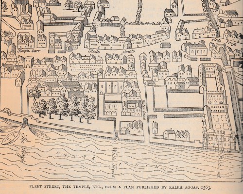
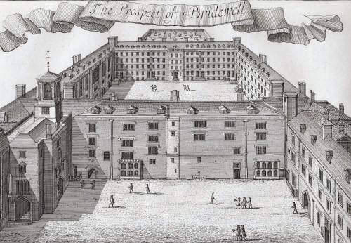
Bridewell, which has now vanished, began as a palace and rapidly deteriorated into a prison. I traced its history here.

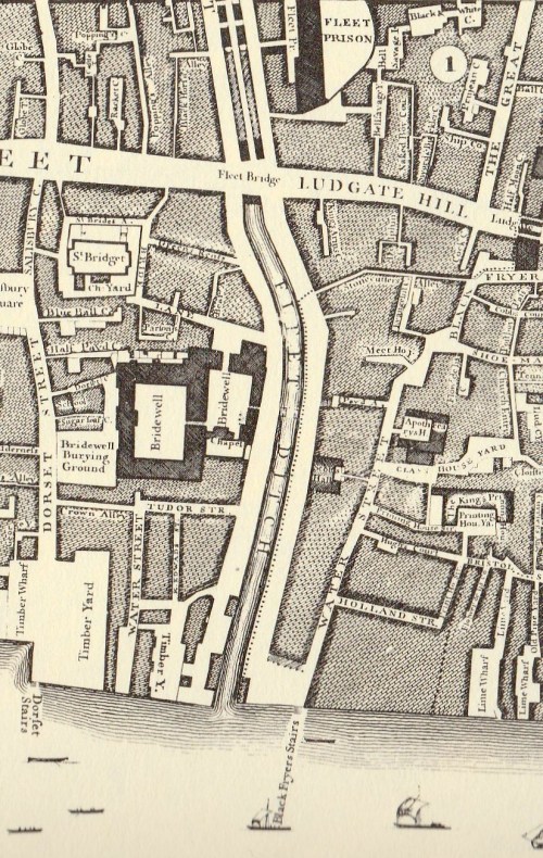
In 1733 the length between the Holborn and Ludgate bridges was covered and became Fleet Market – the double row of stalls can be seen in Roque’s map of 1738/47 (below). The Fleet Prison shows clearly, middle top, – the curve of the wall is still reflected in the building line today.

Below Fleet Bridge the  Bridewell Bridge has disappeared and the Fleet itself is labelled ‘Fleet Ditch’, an apt name by then – it was a stinking mass of refuse. Pope in his Dunciad writes of it:

Fleet Ditch, with disemboguing streams,

Rolls the large tribute of dead dogs to Thames;

The King of Dykes! than whom no sluice of mud,

With deeper sable blots the silver flow.

Or, to quote Ackermann’s rather more prosaic description, “…in the state of a muddy and loathsome ditch, until the building of Blackfriars-Bridge in the year 1768. In the place of this ditch, which had become a serious public nuisance, has sprung up the noble street, exhibited in this view [ie the print above], called New Bridge-street.”

Blackfriars Roque

The original Blackfriars Bridge was begun in 1760 and was finally completed in 1769, although it was open to pedestrians in 1766 and to riders in 1768. It was intended to name it for the Prime Minister, William Pitt, as the remaining inscription still confusingly explains, but popular usage soon had it named for the area, the site of the old Black Friars’ monastery. Repairs took place in 1832, but the bridge deteriorated to such an extent that a new one was proposed. It took years, the building of the Thames Embankment and the demands of the railways, but in 1869 and new bridge was opened. (The parallel railway bridge, just downstream, opened in 1864).

After exploring the area, the marvellous Art Nouveau Blackfriar pub just before the bridge is an excellent place to have lunch and to admire the depiction of the monks who once inhabited the area. (Get there early – it is very popular!)


Leave a comment

Filed under Architecture, Buildings, Maps, Rivers, Transport and travel, Walks

From Palace to Prison – a Short History of Bridewell

prospect-of-bridewell

How does somewhere turn, in the space of thirty years, from a royal palace where the Holy Roman Emperor Charles V was lavishly entertained to a place whose name became generic for prisons for the punishment of vagrants and fallen women?

Bridewell Palace was built for Henry VIII between 1515 and 1520. Its southern façade faced the Thames, its eastern face was on the banks of the River Fleet and it was named for the nearby holy well of St Bride and it was a typical rambling, brick-built Tudor palace around three courtyards. It was the location where Hans Holbein’s famous painting The Ambassadors was set, the venue for masques and celebrations when Charles V visited and the home of Henry’s illegitimate son Henry Blount, Duke of Richmond and Somerset.

Its days as a palace were short-lived after it served as the venue for conferences with the Papal Legate over the royal divorce and Henry’s last meeting with Catherine of Aragon in November 1529. By 1531 it was leased to the French Ambassador and it was there in 1533 that Holbein’s The Ambassadors was painted.

In 1553 Edward VI gave Bridewell away, granting it to the City of London as a home for destitute children and vagrants and as a prison for punishing disorderly and loose women and petty offenders with short periods of incarceration and regular whippings. Queen Mary confirmed Edward’s gift – perhaps not wanting to take back the place of such ill-memories of her mother.

The model of prison, hospital and workrooms proved successful enough for many others to be opened across the country, all called Bridewells. The whippings took place in  public twice a week, there was a ducking stool on the banks of the Thames in 1628 and there were also stocks. The regime appears to have been one of “short, sharp shock”, although it seems doubtful that it was very successful in reducing vagrancy, petty crime and immoral behaviour with no support for its inhabitants once they were released. More fortunate were orphans of City Freemen who were accommodated here for an education before being apprenticed to a trade.

The Great Fire of 1666 destroyed much of the old palace and it was rebuilt in 1667. Judging by the print at the top of this post from a drawing by Jan Kip made in the early 18th century, some of the old Tudor palace survived. It can be seen surrounding the courtyard in the foreground with the 17th century and later additions behind. This version of Kip’s drawing was published in 1720 by John Strype and shows the view from the east – in other words, the artist is hovering above the Fleet River and looking west. The two courtyards of the rebuilt Bridewell can be clearly seen in this detail from John Rocque’s map of 1747 (below) turned to be in the same orientation.

bridewell-roque

Despite the floggings the Bridewell was more liberal than other prisons of the time – it had a doctor in 1700, seventy five years before they were appointed to prisons elsewhere, and in 1788 prisoners were not only given straw for their beds but actual beds to put it in – other gaols had neither beds nor straw. Women were not whipped after 1791. The air quality must have improved somewhat after the Fleet was covered in 1764 with the creation of New Bridge Street down to Blackfriars Bridge (1760-69).

The beds filled with straw can be seen in this print of The Pass-Room at Bridewell, 1808 from Ackermann’s Microcosm of London. Here single women with babies were locked up as punishment for their ‘loose behaviour’. The notice on the wall warns that “Those who dirts Their Bed will be Punished.”

bridewell

Building work and improvements carried on until 1833 when all the Bridewells passed from local control to become part of the government’s prison system. In 1855 the prisoners were transferred to Holloway prison and the buildings were demolished in 1863/4. The only remaining fragment is the façade and gateway of 1802 which is now 14, New Bridge Street.

The outline of the site remains in the block bounded by New Bridge Street to the east, Tudor Street to the south, and Bridewell Place which wraps around the west and north sides. Tudor Street can be seen on the Rocque map and led towards one of the notorious and lawless Alsatias from which many of the inmates of Bridewell probably came.

As with Bedlam, the public could gain admittance to view the unfortunate inmates. Priscilla Wakefield, author of Perambulations in London (1814) wrote, ‘Many of the prisoners who we were permitted to see, were women, young, beautiful and depraved.’ Like much of Wakefield’s moralising writing this fills me with the desire to give her the life-chances those ‘depraved’ young women had and see how she got on!

The print below is from Ackermann’s Repository of May 1812 and shows the view looking south down New Bridge Street from what is now Ludgate Circus where Fleet Street dips down to the Fleet Valley and then rises eastwards up Ludgate Hill to St Paul’s Cathedral. Bridewell is concealed behind the furthest range of brown buildings on the right of the print.

new-bridge-street

This area is included in Walk 8 of my Walking Jane Austen’s London and Walk 9 of Walks Through Regency London.


Save

Save

Save

7 Comments

Filed under Architecture, Buildings, Crime, Rivers