Category Archives: Transport and travel

Perambulations Through Late Georgian London or, All the Best Sights in One Week. Day Four

It’s Thursday, the fourth day of the London sightseeing programme proposed by Nathaniel Whittock in 1836. By now the tourists are either on their knees with exhaustion or getting their second wind after the itineraries described in my previous three posts. They might be relieved to find that there is a fair amount of riding around involved in today’s expedition. This itinerary illustrates more clearly than any of the others how close to the Victorian era these visitors are as they experience engineering marvels and improvements in public transport.

Get into the omnibus or coach that goes to Blackwall.

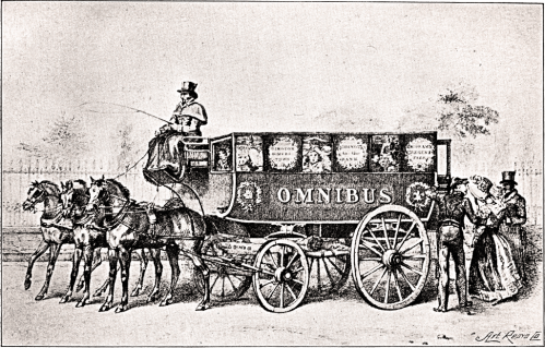
Mr Whittock informs us that “Omnibusses [sic] now run through the leading thoroughfares: their charge is generally stated on the outside of the carriage. At the present time it is as cheap as the most rigid economist could desire as a person may ride in a handsome vehicle from the Bank to Paddington, a distance of four miles, for sixpence.”

George Shillibeer brought horse-drawn omnibuses (shown in the print above) to London in 1829, having seen them operating in Paris. At first they operated with a conductor who took the fares but did not issue tickets. He recorded all the transactions on a waybill, then paid his own, and the driver’s, wages from the money collected and handed the rest over to the bus owner.

An account of the new service was given in the Morning Post of 7 July 1829. “Saturday the new vehicle, called the Omnibus, commenced running from Paddington to the City, and excited considerable notice, both from the novel form of the carriage, and the elegance with which it is fitted out. It is capable of accommodating 16 or 18 persons, all inside, and we apprehend it would be almost impossible to make it overturn, owing to the great width of the carriage. It was drawn by three beautiful bays abreast, after the French fashion. The Omnibus is a handsome machine, in the shape of a van. The width the horses occupy will render the vehicle rather inconvenient to be turned or driven through some of the streets of London.”

see the East and West India Docks


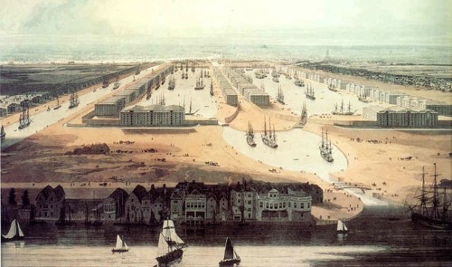
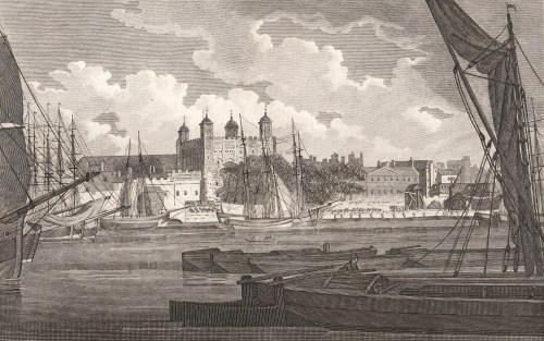
The London docks must have been a spectacular sight, teeming with a mass of sailing ships from all parts of the world. The print is a detail from a painting of 1802, looking west across the neck of the Isle of Dogs towards the City, and showing the West India Dock, opened that year. The import dock is on the right, the dock on the left is for export. The canal on the left later became the South Dock. The East India Docks were slightly to the east at the top of the northward bend of the Blackwall Reach of the Thames. Surrounding the docks were huge secure warehouses with walls thirty feet high and their own guards, an effective protection against the menace of ‘limpers’, ‘water pads’ and ‘water sneaks’ who preyed on the craft moored in the river itself.

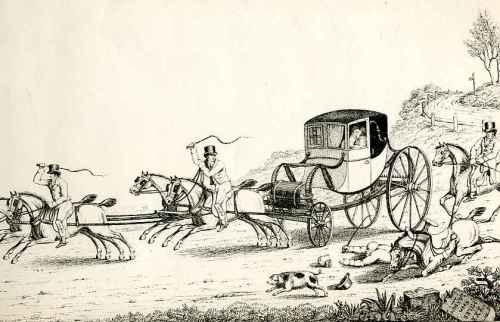
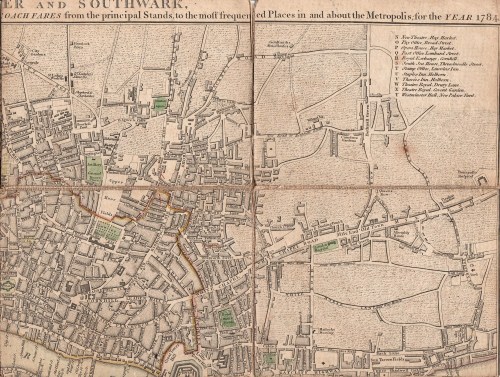
The map shows the docks in 1849.

A short walk thence will take you to the Ferry-House. On crossing the Thames, see Greenwich Hospital.

These days an entire day can easily be spent in Greenwich but Mr Whittock merely invites his readers to admire the exterior of the buildings (he doesn’t even mention the Queen’s House), enter the Great Hall and look up the hill to the Observatory – ‘a conspicuous and celebrated Object.’

Ride on the Railroad as far as Bermondsey;

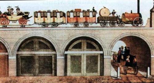
This would have been a real highlight for visitors – the first railway line in London. It was intended only for passengers and was built from London Bridge to Greenwich on a viaduct twenty two feet above the ground and supported on “nearly a thousand arches…intended to be converted into dwelling-houses or places of business.” It cut the journey time from London Bridge to Greenwich from an hour to ten minutes and was the forerunner of all the London commuter lines.

 walk to Rotherhithe, devote an hour to the examination of the Tunnel.

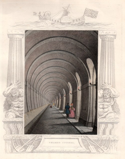
Interestingly, Mr Whittock seems more excited about the Thames Tunnel than he does about the railway. It was certainly an epic piece of engineering, during the course of which Marc Brunel (father of Isambard Kingdom Brunel) invented the tunnel shield which is the basis of all tunnel-boring today. Made essential by the development of the docks, and the problems of building bridges over the Thames to bring the workers from south of the river, it was intended for carriage traffic but instead became a footway and a major tourist attraction. It was converted to take the East London railway line in 1869. The print is from 1835.

Dine at Rotherhithe, and afterwards ride to the Surrey Zoological Gardens.

The Surrey Zoological Society Gardens were founded in 1831 and occupied a site now under Penton Place in Walworth, just north-east of the Oval cricket ground. Impressario Edward Cross sold them the contents of his menagerie at Exeter Change which I blogged about here. It must have been some improvement for the animals who were housed in cages under a circular domed glass conservatory 300 feet (90 m) in circumference. There were lions, tigers, a rhinoceros and giraffes (shown here in 1841) and, for a time, the gardens were more popular than London Zoo in Regent’s Park. However, that was subsidised, and cheaper (the Surrey Gardens cost one shilling admission), so gained in popularity. The gardens, which were lavishly planted and dotted with pavilions, were used for large public entertainments from 1837 – re-enactments of the eruption of Mount Vesuvius, the Great Fire of London, or the storming of Badajoz – and spectacular firework displays. The Great Exhibition of 1851 was the final nail in its coffin and it closed in 1856.

Towards the evening return to dress, and at eight o’clock go by water to Vauxhall.

Vauxhall Gardens lay where the modern park is still situated, close to the Thames and Vauxhall Bridge. Going by water was the traditional way of visiting, even though the first bridge had opened in 1816.

I have blogged about Vauxhall Pleasure Gardens here and also in comparison with their rival, Ranelagh. The print by Cruickshank shows the Gardens in the 1830s, just as our tourists must have seen them.

They would have staggered back to their lodgings late and perhaps a trifle tipsy. Hopefully they get a decent night’s sleep, because Friday will be devoted to the West End, London Zoo, shopping and the theatre.

If you are interested in more of the slang used for London’s criminal classes, including the river thieves, you can find that, and much more, here

1 Comment

Filed under Animals, Architecture, Buildings, Crime, Entertainment, London Parks, Rivers, Science & technology, Transport and travel

How Romantic Was An Elopement?

The romance and drama of an elopement is a popular theme in the historical love story, but it must have been an uncomfortable and expensive procedure, even without the risk of the rope ladder giving way and tumbling the young lady to the ground, or the furious father giving chase with his shotgun or horsewhip to chastise the bridegroom to within an inch of his life.

The post chaise was the fastest and safest way of evading Papa, although the popular name for these vehicles – yellow bounders – hints that expressions of passion must have been difficult as it swayed and lurched along the ill-made roads. How many nervous brides succumbed to travel sickness and second thoughts by the time the first inn was reached?

They also had a reputation for causing accidents because of the furious pace of escape, as a delightful print I picked up in Paris shows. A chaise and four, with the two postilions urging on the horses, leaves mayhem in its wake. A horse falls, its rider spills into the road and a pig bolts in terror while the lovers are lost to everything in their own private world inside the carriage.

The Great North Road by Charles G Harper (1901) casts a cynical eyes at the post chaise and its passengers –

“Everyone is familiar with the appearance of the old post-chaise, which according to the painters and the print-sellers, appears to have been principally used for the purpose of spiriting lovelorn couples with the-speed of the wind away from all restrictions of home and the Court of Chancery. A post-chaise was (so it seems nowadays) a rather cumbrous affair, four-wheeled, high, and insecurely hung, with a glass front and a seat to hold three, facing the horses. The original designers evidently had no prophetic visions as to this especial popularity of post-chaises with errant lovers, nor did they ponder the proverb, ‘Two’s company, three’s none’, else they would have restricted their accommodation to two, or have enlarged it to four.”

The gentleman planning an elopement would do well to visit his banker first – eloping in any style was an expensive business. There were the bribes of course – the lady’s maid, footmen who must turn a blind eye, the gardener whose ladder might be borrowed. The postilions, who would know at once that something illicit was afoot, would need their palms greasing liberally as would the landladies of the inns along the way if the happy, if queasy, couple wanted a good room for their first night of bliss.

The image above is from a book called Takings: or the Life of a Collegian. It is a satirical romp through the life of a young man by R.Dagley (1821). The picture is captioned ‘Taking Amiss’. Here the ‘hero’ Tom is eloping with his love – note the sign on the wall ‘To the Boarding School’ – the young lady is clearly below age.

At length the wished-for moment was at hand.

(Why should Time creep so slowly when we call?)

The cautious signal by the lovers plann’d,

Was heard and answere’d by the garden-wall

And now her drapery the nymph displays,

Now they [Tom has a friend along to support him] assist, and seat her in the chaise.


Not everything goes according to Tom’s plans, however: “One lodging, he conceived, for both would do, But Charlotte resolutely called for two”. Frustrated, Tom settles down to woo her, but has not succeeded by the time her furious relatives locate them and he finds himself facing a duel.

Another significant cost was the hire of the post chaise itself. A prudent lover would hire four horses, to achieve twelve miles an hour, and the chaise cost one-and-threepence a mile. On top of that there were toll gates to pay every few miles and food and accommodation. The canny eloper armed himself with Cary’s New Itinerary or an Accurate Delineation of the Great Roads (as does the writer trying to work out her hero and heroine’s route today!) This at least ensured that the post boys were not adding on a profitable mile here and there.

London to Gretna via Manchester, according to Cary, is 320 miles. That is £20 for the chaise and horses alone, at a time when a housemaid would be glad to earn £16 a year, all found.

Does an elopement still strike you as romantic? Would the thrill of the escape and the delight of being alone with the loved one at last outweigh the discomfort and expense? It is a while since I wrote an elopement into a book – I wonder, should I be thinking of another one?

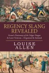
If you are intrigued by the experience of travelling in Georgian Britain you can retrace some of the iconic routes in Driving Through Georgian Britain: the great coaching routes for the modern travellerAvailable in paperback and ebook it allows the modern traveller to drive the Great North Road, the Bath Road, the Brighton Road and the Dover Road finding what remains and discovering stories of elopement, murder, good meals and bare knuckle fights along the way.


4 Comments

Filed under courtship & marriage, Love and Marriage, Sex & scandal, Transport and travel

Just A Dip in the Street? One of London’s Lost Rivers

Last week, on a visit to London, I got off a bus on Ludgate Hill, walked down to Ludgate Circus and turned left down New Bridge Street towards the Thames, ignoring Fleet Street rising up straight ahead. It is something that workers and tourists do in their thousands every day of the week, but I wonder how many of us think about why there is such a steep hill and dip in the street just there. The clue is in Fleet Street and the valley was, of course, caused by the River Fleet, now flowing under New Bridge Street in the guise of a sewer to its virtually invisible outfall in the Thames.

The map below is a section of Cary’s New Plan of London (1784)

Blackfriars

Travelling about London one tends not to notice its dips and hills. I have posted in the past about taking the 23 bus and experiencing the dip not only of the Fleet but also the Tyburn Brook in Oxford Street. On the map above the streets with ‘hill’ names help us map the course of the Fleet. At the top of Fleet Market, formed when the river was covered over in 1733, Holborn Hill and Snow Hill dip down from west and east and the course of the river continues northwards under Saffron Hill.

New Bridge Streetfull size

The image above is from Ackermann’s Repository May 1812, “from a drawing by that eminent artist in water-colour painting, Mr Frederick Nash.” The artist shows the scene as though he is standing in the middle of Ludgate Circus (although the maps of the time do not give the junction a specific name). The bump of Blackfriars Bridge is just visible in the far distance, Fleet Street is to the right and Ludgate Hill to the left.

“The obelisk at the north end of this street, as shewn in the view, was erected to give safety to the public crossing, in the year 1775, during the mayoralty of the celebrated John Wilkes.” (Wilkes (1725 – 1797) was a  radical, journalist, libertine and Member of Parliament. He was also an enthusiastic supporter of American independence although he grew increasingly conservative with age.) The obelisk has long gone, unfortunately.

The Fleet rises on Hampstead Heath, as does the Tyburn, but there is no trace these days other than the three swimming ponds on the Heath. In the Middle Ages it was still navigable by barges as far as Holborn Bridge, to the north of the section in this map of 1563. Fleet Bridge is named and below it was the Bridewell Bridge , “said to resemble to Rialto at Venice” according to Ackermann’s – it  certainly seems to be covered. Before the Great Fire it was made of wood, but was replaced in stone with two arches.

Blackfriars 1563

Bridewell, which has now vanished, began as a palace and rapidly deteriorated into a prison. I traced its history here.

In 1733 the length between the Holborn and Ludgate bridges was covered and became Fleet Market – the double row of stalls can be seen in Roque’s map of 1738/47 (below). The Fleet Prison shows clearly, middle top, – the curve of the wall is still reflected in the building line today.

Below Fleet Bridge the  Bridewell Bridge has disappeared and the Fleet itself is labelled ‘Fleet Ditch’, an apt name by then – it was a stinking mass of refuse. Pope in his Dunciad writes of it:

Fleet Ditch, with disemboguing streams,

Rolls the large tribute of dead dogs to Thames;

The King of Dykes! than whom no sluice of mud,

With deeper sable blots the silver flow.

Or, to quote Ackermann’s rather more prosaic description, “…in the state of a muddy and loathsome ditch, until the building of Blackfriars-Bridge in the year 1768. In the place of this ditch, which had become a serious public nuisance, has sprung up the noble street, exhibited in this view [ie the print above], called New Bridge-street.”

Blackfriars Roque

The original Blackfriars Bridge was begun in 1760 and was finally completed in 1769, although it was open to pedestrians in 1766 and to riders in 1768. It was intended to name it for the Prime Minister, William Pitt, as the remaining inscription still confusingly explains, but popular usage soon had it named for the area, the site of the old Black Friars’ monastery. Repairs took place in 1832, but the bridge deteriorated to such an extent that a new one was proposed. It took years, the building of the Thames Embankment and the demands of the railways, but in 1869 and new bridge was opened. (The parallel railway bridge, just downstream, opened in 1864).

After exploring the area, the marvellous Art Nouveau Blackfriar pub just before the bridge is an excellent place to have lunch and to admire the depiction of the monks who once inhabited the area. (Get there early – it is very popular!)


Leave a comment

Filed under Architecture, Buildings, Maps, Rivers, Transport and travel, Walks

Just How Romantic Were Highwaymen?

I have a vested interest in that question because two of my ancestors were hanged at Aylesbury in Buckinghamshire for highway robbery in the first half of the 18th century – fortunately for me, they had married and left children by then. Not so fortunate for their families. So, were these two handsome masked men on flashy black stallions, setting ladies’ hearts a flutter as they relieved the gentlemen of their coin? I very much doubt it – from what I can establish of these two, and their circumstances, they were probably an unpleasant pair of muggers out for what they could get and unscrupulous about how they got it.

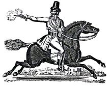
But the highwayman was a popular figure (at least, if you weren’t one of his victims). The crowd loved a villain, especially one who robbed those better off than themselves, carried out daring raids and escapes and, when almost inevitably brought to justice, “died game” on the gallows. Reality was less romantic – even the famous Dick Turpin, shown here on Black Bess, was a violent thug who tortured victims and inn keepers. The dashing Frenchman, Claude du Vall was hanged at Tyburn January 1670 despite (according to legend) gallantly sparing the possessions of any pretty lady who was prepared to dance with him. Presumably the plain ones just got robbed. The Victorians loved him and he was immortalized in a painting by Frith.

So, what was the risk of encountering a highwayman? Up until the third quarter of the 18th century the danger was significant. Roads were bad, so travel was slow and out-running a mounted attack virtually impossible. There was no effective policing of highways and the response of the law was to react to incidents, not to prevent them. The London Gazette in 1684 carried an advertisement offering a reward after the Northampton stage was, ‘set upon by four Theeves, plain in habit but well-horsed,’ and in one week in 1720 every stagecoach into London from Surrey was robbed by highwaymen.

However, as I discovered when I was researching  Stagecoach Travel, although rapid improvements to roads in the later 18th century meant that there were far more vehicles moving over them it also meant that the coaches – increasingly better designed – became faster. Stage and mail coaches were now major businesses with a lot to lose and the guards were better armed and trained. The authorities put mounted patrols on the roads and eventually made the whole business too risky to be worthwhile.It took a while, though – the last incident of highway robbery on Knightsbridge, the road between Hyde Park Corner tollgate and the village of Kensington, was in 1799.

Today as you travel along that route, perhaps on the top of a London bus, look north as you pass the Royal Albert Hall, built on the site of Gore House. Opposite Gore House was the infamous Halfway House Inn (below). There the spies for the highwaymen of Hounslow Heath would congregate to see who was travelling and pass the word on to alert the highwaymen about fine carriages or vulnerable riders.  The wall behind the inn is the boundary of Hyde Park.

Highwaymen did persist longer in Ireland where the roads were less good and the slower coaches made easier pickings. In 1808 a coach lined with copper and advertised as bulletproof was tried on the Dublin to Cork road, an indication that highwaymen were not afraid to shoot into the body of the vehicle at the passengers as well as threaten the guard and coachman.

The highwayman and his less glamorous compatriots were sufficiently significant in Georgian society to have left their mark on the slang of the time as I discovered when I was researching Regency Slang Revealed: Grose’s Dictionary of the Vulgar Tongue.   The mounted highwayman was “on the High Toby” the footpads were on the “Low Pad” or “Low Toby”. I found eleven general terms for a highwayman – a Gentleman’s Master being one that perhaps gives a clue as to why they were popular with the common people. A Bully Ruffian was a very violent highwayman whereas a Royal Scamp preyed on the rich in a most gentlemanly fashion. It seems that equipment was important – a Rum Padder was particularly well-armed and well-mounted and a Chosen Pell was a highwayman operating inside a town, riding a horse with leather covers on its feet to muffle the sound of hoof-beats.

A highwayman’s mistress was his Bloss or Blowen and she may have waited for him at inns like the Halfway House when he went “on the pad” advised by his Carriers or Cruisers – the informants. They would all have hoped for a Catching Harvest – a time when the roads were thronged with travellers going to some event or another. Fairs, boxing matches and races gave particularly good pickings.

Just remember, when you are held up by a highwayman – mention the Music. That’s the universal password that will see you safe.

I’ll leave you with a watercolour portrait that I own. I have no idea of date, artist or subject, but he haunts me. I just have the feeling that he’s a highwayman, no longer in his prime. Should he mount up and take to the High Toby tonight? Or would that be one time too many…


Save

Save

Save

Save

Save

Save

Save

Save

Save

8 Comments

Filed under Crime, Gentlemen, Street life, Transport and travel, Travel

A Slightly Soggy Smile

I bought a few pages from a 19th century scrap book which included this delightful cartoon about the state of London streets. It isn’t dated, but from the men’s clothes I would guess 1820s. St Paul’s can just be seen in the background.

The standing man, who seems to be perched on wooden pattens is saying, “Why friend, you are over shoe tops. Catch hold of my stick and I’ll help you out.”

The other, who it can just be seen is holding reins in one hand, replies, “I thank you, Sir, but I’ve a Horse under me that’s used to bad roads.”

2 Comments

Filed under Street life, Transport and travel

The Tower From the River

Just a short post today – but recently I went to see the exhibition about Emma Hamilton at the National Maritime Museum (stunning, by the way) and travelled by water bus between Greenwich and Westminster. We passed the Tower of London, of course, and it was interesting to compare the view today with this one of 1797.

tower

The biggest difference is the presence of the Embankment and the disappearance of the open space with the cannon to the right- presumably they belonged to the Board of Ordnance who were in the Tower. Now the approach road to London Bridge crosses close to this spot. The water gate, the entrance to Traitor’s Gate can be seen in the print as a crescent shape just to the left of the White Tower.

There are no crowds of tourists taking selfies in this image, but the amount of river traffic is surprisingly close – now it is tourist boats, river buses, the River Police and still quite a few barges and tugs. I wish I’d had this print with me!

Save

1 Comment

Filed under Architecture, Transport and travel, Travel, working life

Paying the Correct Fare – Hackney Carriages and Watermen

I had a wonderful auction haul of prints and maps in December – including the map that I’d gone for in the first place – Cary’s New Plan of London with the Correct List of upward of 350 Hackney & Coach Fares from the Principal Stands to the most Frequented Places in & About the Metropolis. Printed for J.Cary , Map & Printseller, No. 188, Strand.  (1784)

cover

The map measures 550×410 cm (approximately 22×16.5 inches) but has been cut into segments and mounted on a flexible backing so that it folds neatly into its handy pocket-sized slipcase, shown above (145×111 cm/5.5×4.5 inches). From the state of the cover which is intact but worn, it has been well used by its owner, possibly the J. Beauchamp who has written his name on the back of the map.

top-right

I had never seen a map with the hackney coach and watermen’s fares before, although I have guidebooks with some of the same information, so I was fascinated to read in The London Encyclopedia (2008)  “There was a certain amount of dishonesty and overcharging in both groups, so that from about 1720 makers of London maps adopted the practice of printing tables of hackney coach and watermen’s fares on the maps which they published.”

According the the Encyclopedia, hackney carriages were named from the French word hacquené (an ambling nag) and were invented by one of Raleigh’s sea captains at the end of the 16th century.

fares

The section at the bottom of the map gives fares from Charing Cross, Temple Bar, West Smithfield, Borough (ie Southwark), Oxford Street (at the Pantheon), St Paul’s Churchyard, Holborn, Hyde Park Corner, Westminster Hall, Drury Lane Theatre and Covent Garden Theatre. Here is the central portion enlarged:

fares-detail

The “Rates of Oars up and down the River for the whole Fare or Company” run along the bottom of the map and proved very difficult to scan. From London (it doesn’t say from which point) to Greenwich or Deptford it was one shilling and six pence, to Richmond, three shillings and sixpence and to Hampton Court six shillings, to take a few examples.

Mr Beauchamp appears to have found the map useful well beyond 1784 because he (or perhaps a later owner) has inked in three new developments – Brunswick Square, built 1795-1802, the Strand bridge (later known as Waterloo Bridge) of 1811 and the line of Regent Street, which must have been done post-1810, the date of John Nash’s report on the need for the new street. I wonder if this meant that the fares were unchanged or that the map was still useful as a street map.

brunswick-square

strand-bridgeregent-street

Save

Save

Save

Save

11 Comments

Filed under Architecture, Maps, Transport and travel, Travel

The Earl of Wittering Goes to the Seaside: Part 4 The Journey

London to Weymouth

The day has dawned for the Gatwick family to set forth from their Mayfair Town house to their lodgings in Weymouth. Porrett, the Earl of Wittering’s much-tried secretary has driven the route recently, inspecting the available accommodation, but he went by stagecoach. Now he is in charge of the cavalcade of private conveyances his lordship’s party requires.

Cary mapThe first footman, two more footmen, two maids (more of those can be hired locally along with assorted kitchen skivvies) and Gaston the chef, left three days before to set up the house on the Esplanade and hire extra staff and furnishings required. That involved two lumbering old coaches plus a baggage coach.

Now Porrett is mustering a coach for the Earl and Countess; a coach for the heir, Viscount Ditherstone, his wife and children and a coach for himself, the two ladies’ maids, two valets and the dressing and jewellery cases. That is a tight squash, but Porrett is too soft-hearted to make one of the valets travel on the box, even though he easily outranks them in the household hierarchy. Behind them comes another baggage coach, a lighter one this time, which should be able to keep up. That contains the overnight essentials for the family and their wardrobes.Cary front

Porrett has studied the map in Cary’s Map of England and Wales [detail of the route above & slip case of the map  with the frontispiece of the Itinerary] along with Cary’s New Itinerary or an Accurate Delineation of the Great Roads… and knows it is 127 miles and 6 furlongs to Weymouth. [Page one of the route is shown right at the bottom of this post.]

Porrett would like to think they could travel at 10 miles an hour, but experience of the family tells him this is most unlikely, so he is estimating seven mph and has reserved rooms at the Angel Inn in Andover [below], a mere 63 miles and 4 furlongs along the route to allow for an inevitably delayed start. Porrett is braced for the journey – and armed to the teeth, as are the coachmen and grooms – because 9 miles into the journey is Hounslow Heath and, although the heyday of the highwayman is past, it still has a fearsome reputation.

Angel inn

Porrett tightens his fingers around the pistol in his pocket, daydreaming about rescuing Miss Emily from the loathsome clutches of a masked swine on horseback. Oh, Mr Porrett, Frederick… you are so brave, she whispers as he sweeps her up into his arms…

This happy fantasy lasts as far as Staines where Mullett, the viscount’s valet, jabs him in the ribs and inquires acidly if he is in pain, pointing out that they are crossing the Thames. And so onwards, stopping only to change horses at Hook where they refresh themselves at the Raven before passing through Basingstoke to Andover. The next morning Porrett succeeds in getting his travelling circus on the road by ten, which he considers a triumph.

In Salisbury the countess wants to stop to sketch the cathedral, but her husband over-rules this fancy. He has been separated from Gaston the chef and his dinners far too long. From Salisbury to Blandford for refreshments and then on to Dorchester where the Land’s End road that they have been following continues westwards and they turn south to Weymouth.

Finally they draw up in front of their home for almost two months, with the bay and seascape laid out before them. Emily,  young Arthur and the senior Ditherstones are delighted with the scene. The Countess is obviously itching to find her sketch pad. The Earl stomps inside calling for brandy. Porrett braces himself – will his employer like the house?

The next episode of Porrett’s love affair (if only… he sighs) and the family’s activities in Weymouth  will follow here soon. Meanwhile read more about the world of the Georgian seaside in  The Georgian Seaside: the English resorts before the railways came.

And to follow one of the iconic coaching routes (by car, or on Google Streetview from the comfort of your armchair) try Following the Great North Road

route to Weymouth 1

3 Comments

Filed under Seaside resorts, Transport and travel

Looking Down on London Bridge

Last week I went up the Shard on the south bank of the Thames and, knees shaking at the height, looked down on London Bridge, 800 feet below. In the photograph you can see its northern end, the Monument to the Great Fire on Fish Hill and the spire of the church of St Magnus the Martyr.

DSCN7278edit

London Bridge is broken down,
Gold is won and bright renown.
Shields sounding,
War-horns sounding,
Hildur shouting in the din!
Arrows singing,
Mailcoats ringing,
Odin makes our Olaf win!

Not quite the cheery little 17th century nursery rhyme we are familiar with but a Norse poet writing of the attempt of Saxon King Ethelred the Unready (who wasn’t really Unready but Unraed-y – suffering from bad councillors) to recapture London from King Cnut (who never really believed he could hold back the tide, but chroniclers don’t seem to have any sense of irony) with the help of King Olaf of Norway in 1014.
This was the wooden London Bridge that had been rebuilt several times since the Romans left and, for centuries, was the only crossing point in London.
(Oddly, despite burning the bridge, Olaf became a popular saint. His church at the southern end of the bridge is now under an office block bearing his name.)
Even without the intervention of marauding Vikings, wooden bridges needed constant repair, so in 1176 work started on a stone bridge, completed in 1209. All the versions of London Bridge for over a thousand years have been more or less on the same spot, but we know exactly where this one, now known as Old London Bridge, was located because it survived, albeit endlessly adapted, until 1830. DSCN7280edit
The bridge had a drawbridge in it to allow taller ships to pass, gatehouses to guard it – and, from the 14th century, to act as convenient places to stick the heads and assorted limbs of traitors – and a chapel. Almost from the beginning houses and shops were built along the bridge, narrowing the roadway to between 12 and 15 feet (3.7 – 4.6 metres). After the Great Fire in 1666 when some were destroyed they were rebuilt hanging further out over the river, but even so it was hideously congested.
From 1722 tolls were charged on vehicles which meant that they tended to stop in Southwark on the southern side and unload their passengers and goods. Numerous inns grew up to deal with this business. In an attempt to control the flow on the bridge three men were employed to try and enforce driving on the left, the first time a ‘keep left’ rule was applied in England. Stonegate at the southern end was rebuilt in 1728 with a wider arch but even so, when there was a major event at Vauxhall gardens, for example, three hour traffic jams were not uncommon.London Bridge Frost Fair
By the time Westminster Bridge opened in 1750 London Bridge was looking decidedly shabby by contrast and drastic modifications were carried out between 1757-62. All the buildings were demolished, a wider central arch was created and the bridge was widened by 26 feet (8 metres) and refaced in Portland stone. Alcoves were added along its length, some with domes, and the lighting was improved. In 1763 the Stonegate was demolished and arches made in the tower of the church of St Magnus the Martyr at the northern end for pedestrians using the widened road. The clock that overhung the roadway is still there, blocked from the river now by an ugly modern office Monument0002building. In the print looking down Fish Hill you can see the tower of St Magnus and the clock.
Even with the renovations the old bridge was failing and the final straw was the damage in the severe winter of 1813-14 when the last Frost Fair was held on the Thames. (The black and white print above shows one of the arches during the Frost Fair). Work began in 1824 on a new bridge, built alongside the old one so that traffic could continue. The new alignment shifted the approach to the bridge westwards from Fish Hill, site of the Monument, and obliterated the waterworks on the upstream side of the old bridge. The works had waterwheels that took 4 million gallons a day from the river to supply 10,000 customers and they can be seen on the far side in this print of 1814.

Monument0003
The new bridge, designed by John Rennie, opened in 1831 and the old bridge was demolished over the next two years. Rennie’s bridge was replaced in 1972 with the present structure.
So what remains of Old London Bridge? Not a lot, considering what an iconic feature of the London landscape it was for so long. One of the 18thc alcoves is in the grounds of Guy’s Hospital, two are in Victoria Park, Hackney and a fourth in the gardens of a block of flats in East Sheen. A stone from an arch is in the churchyard of St Magnus the Martyr where the clock can still be seen and you can walk through the arch in the tower. There is an excellent model of the old bridge with its houses and shops in the church and an even bigger model in the Museum of London.
If you walk into Southwark and find Newcomen Street you’ll see the King’s Arms, a Victorian pub with a fine stone coat of arms on the front. This used to say GIIR, for George II, and was fixed on the Stonegate, the entrance to old London bridge from the Southwark side, in 1728. When the gate was demolished in 1760 it was removed, the inscription changed to 1760 and GIIIR for the current king, and put up on a tavern that stood in Axe Yard.

DSCN7281edit


4 Comments

Filed under Architecture, Buildings, Monuments, Transport and travel

Curricle Crashes and Dennet Disasters – The Dangers of the Regency Road

On the road 1

In April 1811 Jane Austen was staying with her brother Henry and his wife Eliza at their home 64, Sloane Street and working on the proofs of Sense and Sensibility. Not that this prevented her from getting out and about in London and occasionally borrowing Henry’s carriage: ‘The Driving about, the Carriage being open, was very pleasant. I liked my solitary elegance very much, & was ready to laugh all the time, at my being where I was – I could not but feel that I had naturally small right to be parading about London in a Barouche,’ she wrote on a later visit.
But delightful as travel by coach might be, horse-drawn vehicles were dangerous and accidents were numerous, even if most were minor. In a letter home on 25 April 1811 Jane blames an inciHyde Park pike0001dent at the gates for giving her sister-in-law Eliza a chest cold. ‘The Horses actually gibbed on this side of Hyde Park Gate – a load of fresh gravel made it a formidable Hill to them, & they refused the collar; I believe there was a sore shoulder to irritate. Eliza was frightened, & we got out & were detained in the Eveng. air several minutes.’ You can follow Jane’s London travels in Walking Jane Austen’s London.
The wonderful Henry Alken snr. excelled at drawing horses, but he had a mischievous side and produced numerous prints of carriage accidents. [His Return From the Races is at the top of this post]. These are light-hearted, often mocking the young sporting gentlemen of his day and their ‘boy-racer’ equipages, but the potential for an accident to cause death or serious injury was very real. In one hideous stage coach crash in 1833 the Quicksilver coach overturned as it was leaving Brighton. Passengers were flung out into the gardens along the Steine and impaled on the spiked railings. Alken’s third plate in his Trip to Brighton series shows a stagecoach crash as a result of young bucks bribing the coachmen to let them take the reins and race. Discover more of the dangers of travel by stage or mail coach in Stagecoach Travel.accident

Alken’s ‘comic’ drawings show people thrown onto the rough stones of the road, against milestones or walls, at risk of trampling by the horses or of being injured by the splintering wood and sharp metal fittings of their carriages. One has to assume that like cartoon characters walking off a cliff they all bounce back safely with only their dignity ruffled. Real life would not have been so forgiving.  In this post I am sharing some of the Alken carriage disasters from my own collection.

In  Learning to Drive Tandem (1825) learning to driveAlken shows a young gentleman who has got one of his pair turned around and one wheel off the road. The vehicle is a cocking cart used to transport fighting cocks and below the seat is a compartment ventilated by slats and a small image of a fighting cock on the armrest. In The Remains of a Stanhope (1827) the crash has already occurred, showing just how fragile these vehicles could be. A carpenter has been summoned and the owner is drawling somewhat optimistically, “I say my clever feller, have you an idea you can make this thing capable of progression?”

Stanhope

One of my favourite images is this one of a Dennet gig with the horses spooked by a passing stagecoach. The passengers’ faces as they watch the driver struggling with his team are priceless. Dennet accident sat

Several prints of the time show accidents at toll gates. Either the horses bolted or the driver wasn’t paying attention or perhaps they thought the gate keeper would fling the gate wide as they approached. This one is captioned “I wonder whether he is a good jumper!”

accident at toll gate Young men crashing their vehicles was obviously commonplace, and then as now, showing off to the ladies was also part of the joy of owning a sporting vehicle. Alken was not above titillating his audience with a glimpse of petticoat or a shapely leg, even when the owner of the leg was about to get seriously hurt. In “Up and down or the endeavour to discover which way your Horse is inclined to come down backwards or forwards” (1817) the driver takes no notice at all of his fair passenger vanishing over the back of his fancy carriage. There are some nice details in this print – the two-headed goose on the side panel is presumably a reference to the driver not knowing which way he is going and the luxurious sheepskin foot rug is clearly visible. backwardsIn the same series is an awful warning about the dangers of not choosing your horses with care. Captioned “Trying a new match you discover that they are not only alike in colour weight & action but in disposition.” One young man is heading out over the back of the carriage while his companion is poised to leap for safety amidst flying greatcoats, hats and seat cushions.

Bolting


11 Comments

Filed under Accidents & emergencies, Gentlemen, Regency caricatures, Transport and travel, Travel