
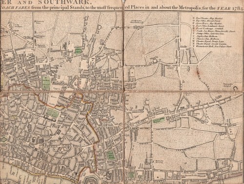
I had a wonderful auction haul of prints and maps in December – including the map that I’d gone for in the first place – Cary’s New Plan of London with the Correct List of upward of 350 Hackney & Coach Fares from the Principal Stands to the most Frequented Places in & About the Metropolis. Printed for J.Cary , Map & Printseller, No. 188, Strand. (1784)

The map measures 550×410 cm (approximately 22×16.5 inches) but has been cut into segments and mounted on a flexible backing so that it folds neatly into its handy pocket-sized slipcase, shown above (145×111 cm/5.5×4.5 inches). From the state of the cover which is intact but worn, it has been well used by its owner, possibly the J. Beauchamp who has written his name on the back of the map.
I had never seen a map with the hackney coach and watermen’s fares before, although I have guidebooks with some of the same information, so I was fascinated to read in The London Encyclopedia (2008) “There was a certain amount of dishonesty and overcharging in both groups, so that from about 1720 makers of London maps adopted the practice of printing tables of hackney coach and watermen’s fares on the maps which they published.”
According the the Encyclopedia, hackney carriages were named from the French word hacquené (an ambling nag) and were invented by one of Raleigh’s sea captains at the end of the 16th century.

The section at the bottom of the map gives fares from Charing Cross, Temple Bar, West Smithfield, Borough (ie Southwark), Oxford Street (at the Pantheon), St Paul’s Churchyard, Holborn, Hyde Park Corner, Westminster Hall, Drury Lane Theatre and Covent Garden Theatre. Here is the central portion enlarged:
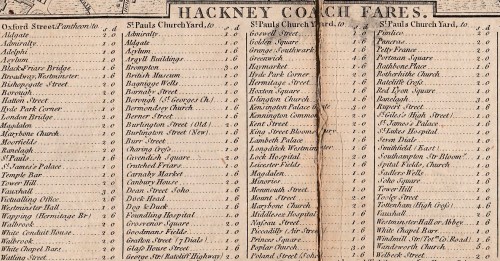
The “Rates of Oars up and down the River for the whole Fare or Company” run along the bottom of the map and proved very difficult to scan. From London (it doesn’t say from which point) to Greenwich or Deptford it was one shilling and six pence, to Richmond, three shillings and sixpence and to Hampton Court six shillings, to take a few examples.
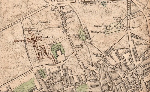
Mr Beauchamp appears to have found the map useful well beyond 1784 because he (or perhaps a later owner) has inked in three new developments – Brunswick Square, built 1795-1802, the Strand bridge (later known as Waterloo Bridge) of 1811 and the line of Regent Street, which must have been done post-1810, the date of John Nash’s report on the need for the new street. I wonder if this meant that the fares were unchanged or that the map was still useful as a street map.


 dent at the gates for giving her sister-in-law Eliza a chest cold. ‘The Horses actually gibbed on this side of Hyde Park Gate – a load of fresh gravel made it a formidable Hill to them, & they refused the collar; I believe there was a sore shoulder to irritate. Eliza was frightened, & we got out & were detained in the Eveng. air several minutes.’ You can follow Jane’s London travels in
 Alken shows a young gentleman who has got one of his pair turned around and one wheel off the road. The vehicle is a cocking cart used to transport fighting cocks and below the seat is a compartment ventilated by slats and a small image of a fighting cock on the armrest. In The Remains of a Stanhope (1827) the crash has already occurred, showing just how fragile these vehicles could be. A carpenter has been summoned and the owner is drawling somewhat optimistically, “I say my clever feller, have you an idea you can make this thing capable of progression?”

 Young men crashing their vehicles was obviously commonplace, and then as now, showing off to the ladies was also part of the joy of owning a sporting vehicle. Alken was not above titillating his audience with a glimpse of petticoat or a shapely leg, even when the owner of the leg was about to get seriously hurt. In “Up and down or the endeavour to discover which way your Horse is inclined to come down backwards or forwards” (1817) the driver takes no notice at all of his fair passenger vanishing over the back of his fancy carriage. There are some nice details in this print – the two-headed goose on the side panel is presumably a reference to the driver not knowing which way he is going and the luxurious sheepskin foot rug is clearly visible.
  In the same series is an awful warning about the dangers of not choosing your horses with care. Captioned “Trying a new match you discover that they are not only alike in colour weight & action but in disposition.” One young man is heading out over the back of the carriage while his companion is poised to leap for safety amidst flying greatcoats, hats and seat cushions.

