
For Jane Austen the Leicester Square area was the location of some of her favourite shops. Until 1630 it was Leicester Fields, common land available for parishioners of any class to dry clothes and to pasture their livestock after Lammas Day (12th August). But London was moving out from its old centres and the Earl of Leicester acquired the area in 1630 in order to build Leicester House. That occupied, more or less, the area between today’s Lisle Street and the Northern edge of the Square. To the East it finished more or less where Leicester Place is and to the West on a line where the edge of the Empire cinema stands. Lisle Street ended at the Western edge of its gardens.

The parishioners were, naturally, unhappy about this incursion on their land and rights and Charles I had to appoint a Privy Council committee to arbitrate. His lordship was ordered to make compensation and he had a high brick wall built along the Southern boundary (the current pavement line, more or less) and, in accordance with the committee’s instructions, had the rest of the land – the present Square – turned ‘into Walkes and planted with trees along the walkes and fitt spaces left for the Inhabitantes to drye their clothes there as they were wont, and to have free use of this place.’ As the other sides of the open area were built on the contractors railed off the centre and planted elms. The map at the top is a detail from Roque’s map of 1740.
In 1670 Leicester Square was laid out for ‘the benefit of the family, the advancement of their revenue, and the decency of the place before Leicester House.’ This was an indication that fine houses were being built around the Square. By the early 18th century there was a brick wall with iron railing and in 1784 a statue of George I in armour and on horseback was moved from the garden of the Duke of Chandos’s house to the centre. The gardens gradually deteriorated and so did the statue which lost a leg. It was finally sold for scrap for £16 in 1872.
Part of the Leicester estate, including the Fields and surroundings was acquired by the Tulk family in 1808. By this time all four sides of the Square were built up with fine houses and no commercial development had been permitted although by 1782 there was a linen draper by the name of Gedge operating at the corner with Cranbourn Street (running from the top Eastern corner of the Square). Six earls had residences in the Square and several artists, writers and men of business lived there. Hogarth created Marriage à la Mode, Rake’s Progress, Industry and Idleness and Gin Lane at no.30 and Joshua Reynolds lived at no.47 from 1760 to 1792. All the fine 17th and 18th century houses have gone now, replaced by buildings of the late 19th century onwards.

By the end of the 18th century the area had become rather less select and had taken on the form shown in the second map above. The Earl of Rockingham had lived at no.27 until his death. It became a bagnio – technically these were bathhouses, but more usually were brothels. This was the location for the great hoax of 1726, the place where anatomist Nathaniel St Andre brought Mary Tofts, a poor women from Surrey whom, he claimed, had given birth to a litter of 15 rabbits after being frightened by one when walking through a field. The story attracted George I’s surgeon who was taken in and claimed to have delivered her of part of another rabbit. Sir Hans Sloane, President of the Royal Society arrived to view the birth of yet more rabbits. Eventually she was caught buying rabbits and the scam was exposed. The bagnio and the sensational hoax perhaps mark the beginning of Leicester Square as a centre for popular entertainment, although as this print of 1812 (from Ackermann’s Repository) shows, it was still a very smart area.
 The view is from Leicester Place down to the North-East corner of the Square. If you stand there today you can still see the indentation in the street on the right hand side – I love how landholdings like this are reflected years later in the modern building line.
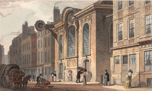
Jane Austen came to the area to shop, especially when she was staying with her brother Henry in Covent Garden. Prices were slightly lower than those in the Mayfair area and she patronised Isaac Newton the linen draper in Leicester Place whose unimaginative approach to window dressing can be seen in this print. Next door is a doorway with a sign over it “Rome Malta” which was the entrance into Barker’s Panorama, opened in 1793. It was a rotunda of 27 metres in diameter. It’s two rooms, one above the other, displayed perspective views of famous scenes and locations which could be viewed ‘in the round’ from the centre
of each room. Jane Austen also shopped for bonnets and caps in Cranbourn Alley. On a snowy day in March 1814 she wrote to her sister Cassandra,
‘Here’s a day! The Ground covered with snow! What is to become of us? We were to have walked out early to near Shops, & had the Carriage for the more distant… Well, we have been out, as far as Coventry St; Edwd escorted us there & back to Newtons, where he left us, & I brought Fanny safely home.’ On that snowy shopping trip she saw, ‘A great many pretty Caps in the Windows of Cranbourn Alley! I hope when you come, we shall both be tempted.’ Intrigued, I set out to find Cranbourn Alley which runs between Cranbourn Street and Bear Street. It is still there – and a horrible little passageway it is now. I wouldn’t want to walk down it in daylight, let alone at night!
By the mid 19th century the ‘garden’ in the centre of the Square was so derelict that it had the Great Globe, a vast ball-shaped panorama built on it in 1851. Later it became a wasteland with occasional circuses, poor quality stalls and was used as a waste tip. It was surrounded by high wooden hoardings covered in advertisements until in 1873 the Master of the Rolls had them removed and ordered that the area be returned to use as a garden. It was rescued in 1874 when it was bought by the flamboyant, and very rich, MP for Kidderminster, Albert Grant, who was created a baron by the King of Italy. He had the garden laid out much as it is today with a fountain and bust of Shakespeare in the centre. It was refurbished in 1992.
It seems difficult to see anything of the Georgian and Regency periods in Leicester Square today with its vast crowds of tourists queuing for theatre and cinema tickets, its souvenir shops and its endless food outlets. However, when I researched the area for Walking Jane Austen’s London and Walks Through Regency London I found plenty of fascinating reminders within a short distance. There’s Freibourg & Treyer’s shop, the oldest surviving in London, in Haymarket. In Gerrard Street you can climb the stairs that Doctor Johnson and Joshua Reynolds would have used in the days when no.9, now a Chinese supermarket, was the famous Turk’s Head coffee house. The area has numerous Regency-era shopfronts too, especially in Lisle Street. Then you can have a drink and sandwich in Tom Cribb’s pub on Panton Street and escape the crush around the Square!
 St Swithen’s was gutted during the Blitz, but remained standing as a ruin, complete with the Stone, until the 1960s when the church was demolished. The photograph below is 1962, just before the demolition. An unlovely building (111, Cannon Street) for the Bank of China was built on the site and the Stone was housed – or, rather, caged – behind bars in the front of this building.(Colour photo).

