Monthly Archives: September 2016

The Story of a Square 2: Berkeley Square

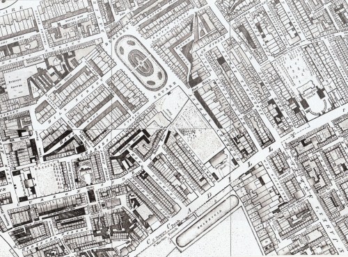
Berkeley (or Berkley as it is often spelled on early maps) Square was built on the farmland owned by John, 1st Baron Berkeley of Stratton, a Royalist military commander in the English Civil War and close friend of James, Duke of York (later James III) who did very well for himself after the restoration of Charles II . Amongst other things he was a co-founder of the Province of New Jersey. Berkeley acquired extensive farmland to the north of the Exeter Road in London, now Piccadilly, and in 1665 he had a mansion built there. Today it would occupy the block bounded by Piccadilly, Stratton Street and Berkeley Street, with its gardens (partly designed by John Evelyn) stretching northwards. In the map below of 1682 ‘Berkley House’ can be seen just above the ‘ETC’  of The Road to Exeter Etc.’ (The area marked ‘St James Park’ is now known as Green Park.)

map-1682

Evelyn records that it cost “neare 30,000 pounds” and called it a “palace”. After Lord Berkeley’s death in 1678 his widow sold off strips at the side of the grounds to create Stratton Street and Berkeley Street, much to Evelyn’s disgust. Princess (later Queen) Anne occupied the house 1692-5 during a spat with her sister Queen Mary and in 1696 it was sold to the Duke of Devonshire and renamed Devonshire House. It was rebuilt after a fire in 1734/7 and this is the house that can been seen in Horwood’s map of 1799/1819. The reservoir in Green Park mentioned in a recent post can be seen at the bottom.

map-horwood

One of the conditions of the sale was that view over the land to the north of the gardens should be unobstructed and this is one reason why, when the area was developed, that Lansdowne House is set to one side with its gardens respecting the view from the rear of Devonshire House and there was no building along the south side of Berkeley Square.

The square was laid out in 1730 with houses on the east and west sides.The east side was the first to be built and was finished about 1738 and the west side was completed in 1745. Of these houses only the western side remains intact – the 1930s saw the replacement of the eastern side and the garden wall of Lansdowne House – and the site of Mr Gunter’s famous establishment in the south-east corner is now under a branch of Prêt. The customers still take their refreshments outside to eat under the plane trees – although rather less elegantly than Mr Gunter’s patrons would have done. It was originally the shop of Dominicus Negri, an Italian pastrycook, who set up there in 1757, trading as The Pot and Pineapple.

In the centre was  an equestrian statue of George III – a not very successful effort whose legs soon collapsed. It was replaced by the little pump house with a Chinese roof which has survived. The famous plane trees are perhaps the most striking survival of the Georgian square and were planted in 1789.

Ackermann’s Repository featured the square in September 1813 with this view which appears to be the south-west corner with the wall of Lansdowne House’s gardens in the background.

ackermann-1813

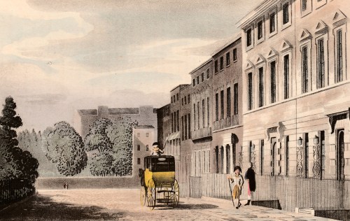
According to the text “This square is distinguished from all the others in the British metropolis by its situation on the side of a hill, which gently slopes from north to south. the houses on the north side are, upon the whole, rather mean; those which form the east and west sides, though many of them, individually, very good buildings, do not, from the want of regularity, appear altogether to such advantage as where greater attention is paid to that point, and where the site is more favourable to it… The area, which forms an oblong square, containing about three acres, is inclosed by an iron balustrade; and the inhabitants, after the example of their neighbours, have, of  late years, caused it to be planted extensively with shrubs, which have thriven very rapidly, and give a rural air to the whole.”

victorian

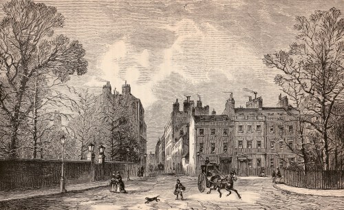
This late Victorian print shows the southern end of the square, looking west with the Lansdowne wall on the left.

Nowadays it needs some care to recapture the Georgian spirit of the square, but it can be done, especially when sitting in the shade of the plane trees and looking at the wonderful ironwork of the western side. But don’t expect to hear a nightingale singing in Berkeley Square – they probably flew off in the 1730s when the builders moved in!

You can visit Berkeley Square on the Mayfair walk in my Walking Jane Austen’s London.

Save

Save

Save

Save

1 Comment

Filed under Architecture, Buildings, High Society, Walks

Captain James Cook 1728-1779

Jane Austen was born in 1775, four years before Captain James Cook was killed in Kealakekua Bay in the Hawaiian Islands, so he might seem somewhat early for this blog. Yet Cook was one of the pioneering explorers and scientist who created the world Jane lived in, a world of scientific discovery and dynamic maritime trade with London at its centre. (The portrait below is c1775, by Sir Nathaniel Dance-Holland)

Plus I seem to be bumping into Captain Cook everywhere I go on holiday!

captainjamescookportrait

At the age of eighteen, after a prosaic start in life on a Yorkshire farm and as a shopkeeper’s assistant, Cook was apprenticed to John Walker, master mariner, at Whitby. The red house in the photo is where Cook lived, occupying the attic with the other apprentices.apprentice-house


This is where I met him most recently, landing by Zodiac from a small ship and seeing the lovely little port somewhat as Cook had seen it. A half-scale replica of his little ship, The Endeavour, is tied up in the harbour (picture below, right). Even at twice the size it is hard to imagine circling the globe in her.

In 1755 Cook, by then a mate on a merchant ship, joined the Royal Navy as a volunteer and proceeded to demonstrate what a farmer’s son, with a village school education, talent and ambition could achieve in the navy. By 1763, at the age of thirty five he was appointed Surveyor of Newfoundland and in 1768, Lieutenant Cook, in command of the Whitby collier Endeavour, was tasked with sailing to Tahiti to observe the transit of Venus in 1769.

endeavour

Observations of the planet Venus passing in front of the sun from various positions on the globe would, the astronomer Edmond Halley predicted, enable the distance of the earth from the sun. (Too complicated to go into here, but there’s a useful explanation on this site).

The Admiralty needed a navigator with exceptional accuracy and rigour and had chosen well: Cook made the observation successfully, then went on to complete the circumnavigation of New Zealand, landing in the bay he called Ship Cove. He revisited the Cove again on his voyage. He went on to survey the east coast of Australia, landing at Botany Bay. (Below: Ship Cove by John Webber, 1778 and the modern memorial in the cove)

ship-cove

cook-memorial

Cook returned home in 1770 and was then sent on his second great voyage in 1772 which involved sailing around the world from west to east, making Cook the first man to have circumnavigated the globe in both directions. He explored far into the south towards what we now know is Antarctica, seeking for the great southern landmass that was believed to exist. His was the first crossing of the Antarctic Circle and he returned with evidence that the southern continent, of which Australia was supposed to be part, did not exist.

He landed in New Zealand again and we were lucky enough to visit Pickersgill Harbour, a tiny, wild patch in the South Island’s fjord area that Cook had used for observations. It still looked just as the artist had depicted, even to the fallen trees that Cook made such good use of – ideal for the shallow-drafted Endeavour. (Below: on-site information board and Pickergill Harbour today)

dusky-sound-notice

pickersgill-harbour

On his way home Cook explored Easter Island, the Tongan Islands, aNew Caledonia and the New Hebrides, returning in 1775.

On his third voyage , beginning 1776, he landed in Tasmania, revisited New Zealand and landed in Tahiti and Tonga. In 1778 he was the first westerner to see the Hawaiian islands but carried on to attempt to pass through the Bering Strait. Stopped by ice he returned to winter in Hawaii, but on 14th February 1779 he was killed, along with four marines, when a dispute with the islanders exploded into violence.

It was a tragic incident, not least because Cook had been rigorous in setting out rules for his crew to ensure their interactions with the local people was peaceful and fair wherever he landed. It seems that Hawaiian society was very different from the southern Pacific peoples he had become used to and a series of tragic misjudgements and misunderstandings led to the fight.

His body was disembowelled, baked and the bones carefully cleaned and removed, all in accordance with local customs showing respect for dead chiefs and important elders. The crew managed to reclaim some of the remains which were buried at sea.

Cook was only fifty one at the time of his death and one wonders what discoveries he would have made if he only had a few more years to explore.


Save

Save

Save

Save

Save

Save

Save

3 Comments

Filed under Science & technology, Travel

The Story of a Square 1: Cavendish Square

Roque Cav SqIn 1717 the 2nd Earl of Oxford, Edward Harley, began work on the development of his estates north of  “the road to Oxford” or Tyburn Road, that eventually became Oxford Street. The first element in his grand design was Cavendish Square, named for his wife Lady Henrietta Cavendish Holles. The Duke of Chandos bought the entire northern side for a mansion (described by Ackermann’s as a ‘palace’), Lord Harcourt and Lord Bingley bought sites on the east and west and the rest was sold to speculative builders. Work was interrupted by the financial crisis of the South Sea Bubble in 1720 but the Earl persisted, developing streets and Oxford Market to stimulate interest in his scheme.

By the time of Roque’s map (1738) there was significant development on all except the North side. Marylebone Bason, a reservoir, can be seen to the north west and what is probably a gravel workings to the north east.  Oxford Street can just be seen at the bottom.Lady Mary Wortley Montagu (poet, letter writer and pioneer of smallpox vaccination) lived at number 5 1723-38.  On the western edge is the beginning of the Earl’s own house which was never completed and eventually the site changed hands and a Mr Tufnell had numbers 11-14 built there in 1771. By 1815  Cav Sq Regencythe Bason and the gravel workings to the north had completely vanished under streets and houses and the whole square had been developed as can be seen in the map to the right.

The centre of the northern side has a gap leading to the mews with a turning circle for carriages. The flanking houses still exist, virtually unchanged outwardly, although the gap between them has a link which carries a sculpture by Epstein.

The house on the north-western corner (now no.16) was one of the wings of Chados’s intended ‘palace’. It was the home between 1761-80 of Princess Amelia, one of the daughters of George III. Amelia suffered form serious ill-health, including tuberculosis of a knee joint and the painful skin disease, St Anthony’s Fire. She spent much time at Weymouth taking sea water cures. Tragically she fell in love with Colonel Charles Fitzroy (descended from one of Charles II’s illegitimate sons). She was not permitted to marry him, but considered herself his wife and left everything to him on her death in 1810, aged 27. In the print below the house is the red brick one on the extreme left. It was ‘modernised’ in the later 19th century so the exterior looks a little different now. Lord and Lady Nelson lived in the Square in 1791 and George Romney, the painter at number 32 on the south side (1775-97).

Cavendish Square

The print of the north side is from Ackermann’s Repository, March 1813. Using Google Street View from the same spot Princess Amelia’s house is still clearly identifiable under later remodeling, a more recent house has been inserted into the space where there is a wall topped with urns and the two houses flanking the entrance to the mews look identical. The circular garden at the centre of the square is till there, but now has an underground carpark beneath it (installed 1971) and the appearance of the square is seriously compromised by the brick wall and entrance lanes of the car park.

I’ll be finding more London squares from my collection of Ackermann prints and seeing how they have changed in future posts.


Save

Save

Save

Save

Leave a comment

Filed under Architecture, Buildings, Royalty