
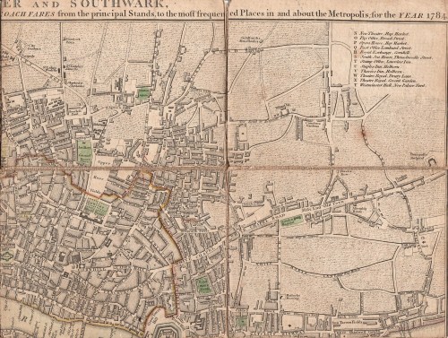
I had a wonderful auction haul of prints and maps in December – including the map that I’d gone for in the first place – Cary’s New Plan of London with the Correct List of upward of 350 Hackney & Coach Fares from the Principal Stands to the most Frequented Places in & About the Metropolis. Printed for J.Cary , Map & Printseller, No. 188, Strand. (1784)

The map measures 550×410 cm (approximately 22×16.5 inches) but has been cut into segments and mounted on a flexible backing so that it folds neatly into its handy pocket-sized slipcase, shown above (145×111 cm/5.5×4.5 inches). From the state of the cover which is intact but worn, it has been well used by its owner, possibly the J. Beauchamp who has written his name on the back of the map.
I had never seen a map with the hackney coach and watermen’s fares before, although I have guidebooks with some of the same information, so I was fascinated to read in The London Encyclopedia (2008) “There was a certain amount of dishonesty and overcharging in both groups, so that from about 1720 makers of London maps adopted the practice of printing tables of hackney coach and watermen’s fares on the maps which they published.”
According the the Encyclopedia, hackney carriages were named from the French word hacquené (an ambling nag) and were invented by one of Raleigh’s sea captains at the end of the 16th century.

The section at the bottom of the map gives fares from Charing Cross, Temple Bar, West Smithfield, Borough (ie Southwark), Oxford Street (at the Pantheon), St Paul’s Churchyard, Holborn, Hyde Park Corner, Westminster Hall, Drury Lane Theatre and Covent Garden Theatre. Here is the central portion enlarged:
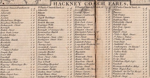
The “Rates of Oars up and down the River for the whole Fare or Company” run along the bottom of the map and proved very difficult to scan. From London (it doesn’t say from which point) to Greenwich or Deptford it was one shilling and six pence, to Richmond, three shillings and sixpence and to Hampton Court six shillings, to take a few examples.
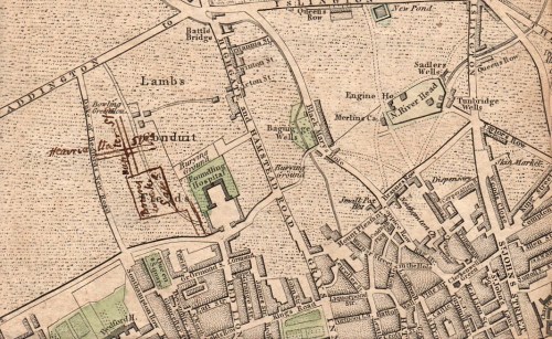
Mr Beauchamp appears to have found the map useful well beyond 1784 because he (or perhaps a later owner) has inked in three new developments – Brunswick Square, built 1795-1802, the Strand bridge (later known as Waterloo Bridge) of 1811 and the line of Regent Street, which must have been done post-1810, the date of John Nash’s report on the need for the new street. I wonder if this meant that the fares were unchanged or that the map was still useful as a street map.


Fascinating, Louise. And I have Regency writer’s envy, a perennial problem when I see your collection of prints!
What an interesting thing to own.
I couldn’t resist it – and when I went to the auction I came away with four more maps and an armload of prints. I’m not safe out, really
Who can resist an old map?
Once again, Louise, you and I are on the same wave length. I have the same kind of pocket map, with fares, from 1799 in a pasteboard slipcase. Not Cary’s, but otherwise identical to yours. It’s one of my most prized possessions, as I am something of a map freak! Found it many years ago at an antiquarian book fair. I’m not safe out, either. 🙂
Awful, isn’t it? Had to call in an architect yesterday to discuss an extension to house the library!But DH amazed when he found the Cary on-line at 4 times the price I paid for it (including restoration of the backing). Not that I’d sell it.
Pingback: All Things History – Monthly Roundup for January 2017 – All Things Georgian
Pingback: The History of the Word "Hacker" | Deepgram
Hi. I recently discovered a similar map in a picture frame in my Dad’s garage. (Must be original because it is on the linen backing for folding up by the carriage drivers at the time I guess) Its a ‘Drew’s’ map showing more detailed fares to different places of entertainment such as Sadler’s Wells and the Opera House. Can anyone tell me whether this is valuable, rare etc.? Happy to upload a picture but I’m not sure how to do that
sorry, have only just picked this up. This sounds like this one https://digital.libraries.psu.edu/digital/collection/maps1/id/30409/. Depending on condition I would have thought it is worth c£100, possibly more. Published 1801. I’d get it out of the light and any risk of damp. Might be worth consulting your local auction rooms if you have one that’s got a good book & map department
Pingback: The History of the Word "Hacker" - Deepgram